|
||

|

|
|

|
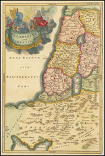
Fine example of the "reduced" edition of Conder & Kitchener's Map of Western Palestine, issued in 1881.
The original map created by Conder & Kitchener consists of 26 sheets and is ordinarily found bound in atlas format.
The present example of the map is the first reduced version of the map. The following year, a number of variant thematic issues were issued with different information, including the Old Testament, New Testament and Geographical editions.
Field Marshal Horatio Herbert Kitchener, 1st Earl Kitchener, was an Irish-born British Field Marshal and proconsul who won fame for his imperial campaigns and later played a central role in the early part of the First World War, although he died halfway through it. In 1874, at age 24, Kitchener was assigned by the Palestine Exploration Fund, to a mapping-survey of the Holy Land, replacing Charles Tyrwhitt-Drake, who had died of malaria. Kitchener, then an officer in the Royal Engineers, joined fellow Royal Engineer Claude R. Conder and between 1874 and 1877 they surveyed what is today Israel, the West Bank, and Gaza, returning to England only briefly in 1875, after an attack by locals in the Galilee, at Safed.
Conder and Kitchener's expedition became known as the Survey of Western Palestine because it was largely confined to the area west of the Jordan River. The survey collected data on the topography and toponymy of the area, as well as local flora and fauna. The results of the survey were published in an eight-volume series, with Kitchener's contribution in the first three volumes (Conder and Kitchener 1881-1885).
![[ Paradise ] De Gelegentheyt van t'Paradys ende t'Landt Canaan, Mitsgaders de Eerst Bewoonde Landen Der Patriarchen uyt de H. Schrifture en verscheyden Auctoren by een gestelt door Nicolaes Visscher](https://storage.googleapis.com/raremaps/img/small/85711.jpg)
![[Untitled Map of the Holy Land]](https://storage.googleapis.com/raremaps/img/small/87770.jpg)
![[ Promised Lands to the Bordes of Elam or Persia ] Vorstellung der Gegenden zwischen dem gelobten Land und den Grenzen von Elam oder Persien, wie sie in den alten Zeiten bekannt gewesen.](https://storage.googleapis.com/raremaps/img/small/94693.jpg)