|
||

|

|
|

|
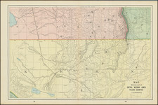
Interesting early 20th Century map covering parts of Solano, Napa, Yolo, Colusa, and Glenn Counties, locating the earthquake Fault Lines in the region.
The map features annotations for geological formations such as anticlines and synclines, as well as indications of fault lines and the angles of geological dips. Additionally, it marks the locations of well-drilling sites that have been abandoned, with a reference to consult the text for further details. This map serves as a scientific representation of the Sacramento Valley's complex geological structure during the early 20th century, offering a valuable snapshot of the region's potential for mineral and oil exploration at that time.
The legend is concise, providing clear symbology for the geological features depicted. Anticlines and synclines, which are upward and downward folds in the Earth's strata, respectively, are distinguished by straight and wavy lines, indicating the map's focus on structural geology. The "Fault" is denoted by a single line, signifying the fractures in the Earth's crust where there is evidence of significant displacement. The "Dip" is represented by a numeric angle, providing insight into the inclination of rock layers, essential for understanding the subterranean composition.
The production of this map by the California State Mining Bureau, with Fletcher Hamilton as the State Mineralogist and L. Vander Leck as the Geologist, is reflective of the period's scientific endeavors to understand and utilize the state's natural resources. As a part of the broader geological survey, such maps were crucial for mining and oil drilling industries, which sought to identify resource-rich areas.
![Parts of E. California and S. E. Nevada, N.W. Arizona and S.W. Utah __ Atlas Sheet No. 66 [Shows Las Vegas!]](https://storage.googleapis.com/raremaps/img/small/92030.jpg)
![(Oil Wells - Santa Fe Springs, Los Angeles County, California) Sante Fee Springs [sic]](https://storage.googleapis.com/raremaps/img/small/95397.jpg)