


|
||

|

|
|

|
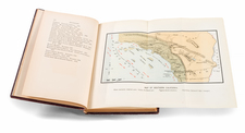
Rare early map of San Diego, published in the mid-1880s.
The map is color coded by an early user, almost certainly to show San Diego County Supervisorial Districts. The supervisorial districts in San Diego were numbered 1 to 5 beginning in 1889. Prior to 1889, the supervisorial districts were set up differently with the County represented by four districts and at large members when the County was founded in 1850.
The map was published in the decade following the creation of Pascoe's map of San Diego, the earliest obtainable map to show the Pueblo lands.
Since the time of Pascoe's map in the early 1870s, much of the waterfront Pueblos lots have been subdivided and, including Old Town, Middletown, New Town and some of the additions east of New Town, along with La Playa and the area around today's Lindbergh Field.
Two early wharves are shown, along with the Coal Station Depot, Russ School in the future Balboa Park area and Railroad Depot Grounds south of downtown.
The course of the San Diego River has been turned and is flowing into False Bay.
The printer Crosscup & West of Philadelphia, seem to have been active published maps primarily in 1879 and 1886. Similarly, Oliver Sanford was active as a mapmaker in San Diego from about 1881 to 1887.
![[ Southern California Tourism ] Hunting and Fishing in Southern California on the Santa Fe](https://storage.googleapis.com/raremaps/img/small/101613.jpg)
![[Early Landsat Photograph of San Diego]](https://storage.googleapis.com/raremaps/img/small/90466.jpg)
![[ University Heights / Mission Cliff Gardens / San Diego ] Referee's Map of Portion of Lote 3 of Pueblo Lot IIII under Interlocutory Decree in suit of Robert M. Boldick vs. Anna M.D. Wingfield.](https://storage.googleapis.com/raremaps/img/small/96428.jpg)