|
||

|

|
|

|
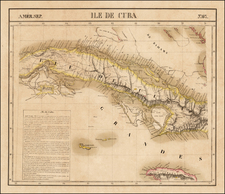
Interesting map of Cuba shortly after the Spanish American War, highlighting its roads and railroads.
Cuba's Railroads in the Early 20th Century
The inclusion of 13 railroads in attests to Cuba's rapidly expanding railroad network during the early 20th century. At this time, the railroad system was crucial in connecting Cuba's primary ports with the interior, especially the agricultural zones.
The first decades of the 20th century witnessed significant investments in Cuba's rail infrastructure, driven by the booming sugar industry. Railroads facilitated the efficient transport of sugar cane to mills and ports, and the connectivity they provided helped integrate various regions of Cuba. Foreign investments, primarily American, played a vital role in the expansion and modernization of the rail system, making it one of the most extensive in Latin America.
Rand McNally & Co. is a large American map and navigation company best known for its annual atlases. The company got its start in 1856, when William Rand opened a print shop in Chicago. He was joined in 1858 by a new employee, Andrew McNally. Together, the men established their namesake company in 1868. Originally, the company was intended to print the tickets and timetables for the trains running to and through Chicago; their first railway guide was published in 1869.
By 1870, they had shifted from just printing to publishing directories, travel guides, and newspapers. Their first map appeared in 1872 in a railway guide. The map was produced using a new wax engraving method, a cheaper process that gave the company an edge.
By 1880 Rand McNally had entered the education market with globes, wall maps, and geography texts for students. In 1923, Rand McNally published the first Goode’s World Atlas, named after its editor, Dr. J. Paul Goode. For generations afterward, this would be the standard classroom atlas.
In 1899, William Rand left the company, but McNally and his family remained, controlling the company for over a century. In 1904, they published their first road map intended for automobiles and by 1907 were publishing Photo-Auto Guides, which combined photography and mapping to help drivers. In 1924, they produced the Auto Chum, a precursor to their famous road atlases. Rand McNally would remain the leader in road maps and atlases throughout the twentieth century.
In 1937, Rand McNally opened its first store in New York City. Ever on the frontier of technology, Rand McNally pioneered the scribing process for printing tickets in 1958 and printed their first full-color road atlas in 1960. Arthur Robinson developed his now-famous projection of Rand McNally in 1969. By the 1980s, the company was exploring digital reproduction and digital databases of maps for truckers. In the 1990s, they lead the charge to develop trip-planning software and websites. Today, most of its products are available online or in a digital format, including maps for tablets and phones.

![[ Charleston, Boston, New York, St. Augustine, Bahamas, etc ] Particular Draughts of some of the Principal Towns and Harbours belonging to the English French and Spanish in America and the West Indies.](https://storage.googleapis.com/raremaps/img/small/102804.jpg)
![[Havana / Approved by the Chart Committee of the Admiralty] Plan of the Harbour and city of the Havana, surveyed by Don Joseph de Rio, Captain in the Spanish Navy. 1798 . . . 1805](https://storage.googleapis.com/raremaps/img/small/89455.jpg)