|
||

|

|
|

|
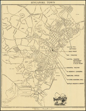
One of The Earliest Printed Views and Plans of Singapore
This rare early birdseye view and plan of Singapore (with text) offers a fascinating glimpse into the nascent stages of the city, approximately ten years following its establishment by Sir Thomas Stamford Raffles in 1819.
The upper section of the piece features a serene and detailed birdseye view of early Singapore, as seen from Government Hill. The perspective covers pivotal areas such as the burgeoning commercial stretch along the Singapore River, the residential and administrative district known as the Plain, and the densely populated Chinatown. The view, originally based on a painting by Royal Navy Captain Robert James Elliot, encapsulates the city's early vibrancy, showcasing a multitude of buildings, thriving port activities, and a diverse mix of ships, suggesting Singapore's rapid growth as a regional trading hub.
Below the panoramic view is a meticulously drawn plan of the city, labelled "Plan der Stadt Singapore." This map segment provides a structured layout of streets, significant buildings, and the town's fortifications, offering insights into the urban planning and architectural style of early 19th-century Singapore. The delineation of the city is marked by clear and orderly streets, signifying the British colonial influence on urban development and organization.
The accompanying text on the verso, presented in German and French, elaborates on the historical context of this burgeoning colonial outpost. It notes the city's significant increase in population and diversity, with a considerable number of Chinese, Malays, and Indian inhabitants, alongside a smaller European community, giving facts up to 1827.
Textual Analysis: The accompanying texts, in German and French, offer a profound narrative on Singapore's establishment and demographic evolution. The settlement, described as highly important and flourishing, was transformed from a minor fishing village into a crucial trade center and free port, attracting a diverse population due to its burgeoning commerce.
-
Founding and Sovereignty: Singapore was founded at the beginning of 1819 by the British and came under their full sovereignty in 1824, reflecting geopolitical changes in the region.
-
Population Growth: Starting from a few hundred Malay fishermen in 1819, the population surged to 10,683 by 1824, and by 1827, it reached 18,732, showcasing rapid growth and economic opportunity. This did not include 2,500 foreigners, 1,800 soldiers, and 600 convicts, indicating a complex, multi-ethnic community.
-
Demographic Details: The detailed demographics in 1827 showed a diverse population, including 6,088 Chinese, 4,700 Malays, 1,242 Bugis, 777 from the Coromandel and Malabar coasts, among other ethnic groups. This multicultural makeup underlines Singapore’s role as a melting pot of cultures and ethnicities from early on.
-
Urban Structure: The city was divided into three distinct areas: the Malay area housing the Sultan of Johore's residence; the European quarter with public buildings, barracks, etc.; and the Chinese city, indicative of the ethnic compartmentalization that characterized early Singapore.
Rarity
The view and plan are extremely rare.
The only source we could identify for this map suggests that it was included in a German Children's book, entitled Bertuch-Bilderbuch für Kinder enthaltend eine angenehme Sammlung von Thieren, Pflanzen, Blumen, Früchten, Mineralien, Trachten, published in Weimar from about 1790 to the 1820s, although curiously, the title page of the volume illustrated is the 11th Volume and dated 1824.