|
||

|

|
|

|
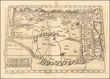
Fascinating engraved map of the Nile north from Aswan, with extensive labeling of the sites along the river.
Expeditions further down the Nile did not proceed successfully until the 19th century; Abu Simbel, for instance, was not discovered until the second decade of the 19th century, and the source of the Nile was not definitively discovered until Speke arrived there in 1858. Thus, this map represents to a large extent the authoritative knowledge of the Nile River.
Jean-Baptiste Bourguignon d’Anville (1697-1782) was one of the foremost French geographers of the eighteenth century. He carried out rigorous research in order to create his maps, which greatly developed the technical proficiency of mapmaking during his lifetime. His style was also simpler and less ornate than that of many of his predecessors. It was widely adopted by his contemporaries and successors.
The son of a tailor, d’Anville showed cartographic prowess from a young age; his first map, of Ancient Greece, was published when he was only fifteen years old. By twenty-two, he was appointed as one of the King’s géographes ordinaire de roi. He tutored the young Louis XV while in the service to the Crown. However, royal appointment did not pay all the bills, so d’Anville also did some work for the Portuguese Crown from 1724. For example, he helped to fill out Dom João V’s library with geographical works and made maps showing Portugal’s African colonies.
D’Anville disapproved of merely copying features from other maps, preferring instead to return to the texts upon which those maps were based to make his own depictions. This led him to embrace blank spaces for unknown areas and to reject names which were not supported by other sources. He also amassed a large personal map library and created a network of sources that included Jesuits in China and savants in Brazil. D’Anville’s historical approach to cartography resulted in magnificently detailed, yet modern and academic, maps. For example, his 1743 map of Italy improved upon all previous maps and included a memoir laying out his research and innovations. The geographer also specialized in ancient historical geography.
In 1773, d’Anville was named premier géographe de roi. In 1780, he ceded his considerable library to the Ministry of Foreign Affairs to be used for as a reference library for diplomats. D’Anville is best known for several maps, including his map of China, first published in 1735, and then included with Du Halde’s history of that country (the Hague, 1737). His map of Africa (1749) was used well into the nineteenth century.
![Карта Восточной Части Африки [Map of the Eastern Part of Africa]](https://storage.googleapis.com/raremaps/img/small/66634.jpg)
![[ Egyptian Coast Guard - The Cost of Coastal Defenses ] Carte de la Cote d'Egypte de Sidi Abd el Rahman jusqu'a Suez indiquant le Service des Gardes Côtes](https://storage.googleapis.com/raremaps/img/small/99465.jpg)