


|
||

|

|
|

|
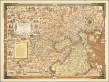
First Map of the Battle of Bunker's Hill Printed In Boston
Extremely rare American engraved plan of Boston and Bunker's Hill, engraved by John Norman in Boston.
This plan is here in its most sought-after form: the first American edition of an image which was adapted from an inset on Sayer & Bennett's The Seat of War in New England published in London in 1775. In addition, it is one of the first maps engraved by John Norman, who would go on to a career as one of the most important American map and chart makers of the late 18th Century, perhaps best known for his American Pilot.
The present plan was originally issued bound into the very rare first American edition of James Murray's An Impartial History of the War in America (Boston: 1781-1782). The area covered includes all of Boston and Charlestown. Charlestown is in flames following a bombardment by the British and the final phase of the Battle of Bunker`s Hill is at its height.
The British regular troops (having been repulsed twice) are advancing on the American redoubt, the famous "rail fence," and the Continental irregulars under William Prescott and Israel Putnam. A Royal Naval squadron are shown firing into the American positions from the Charles River and Boston Harbor. An integral engraved key names all the most important Boston streets and other locations, and lists the sites of the fires that were doing such damage.
The present work was one of the first produced by John Norman. He was born in England in 1748, but by May 1774 was advertising himself in Pennsylvania as an "Architect and Landscape Engraver". He moved to Boston in 1781, and later in his career went on to make his mark as one of the pioneer American mapmakers who moved quickly to fill the gap left in the market by the collapse of the supply of English-made maps to the newly independent United States. His most famous subsequent work is the American Pilot first published in Boston in 1791.
This view is appeared in volume 1 of An Impartial History of the War in America, between Great Britain and the United States, from its commencement to the end of the war. (Boston: Printed by Nathaniel Coverly and Robert Hodge, at their office in Newbury-street, 1781, 1782 and 1784), however most copies of this work are defective and frequently lacking the map.
This is one of the rarest of all American printed battle plans.

![Belgii Pars Septentrionalis communi nomine Vulgo Hollandia…[Inset Views of New Amsterdam (New York City) & Batavia and Maps of NE United States and SE Asia]](https://storage.googleapis.com/raremaps/img/small/78398.jpg)
![[ Marqus de Lafayette -- A letter written from prison ] Extrait d'une note ecrite, dans la prison de Neiss en Silesie, Par le General Lafayette](https://storage.googleapis.com/raremaps/img/small/103827.jpg)