


|
||

|

|
|

|
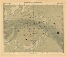
Illustrating The Eclipse of April 1,1764
Fascinating eclipse map, utilizing a Sepia overprinting for the map of Europe, with the progressive intensity of the Solar Eclipse of April 1, 1764 shown.
The shows the projected path of the Moon's shadow across the surface of this part of the Earth during the notable central and annular solar eclipse that occurred on April 1, 1764. The title can be translated from French as: "Helio-Seleno-Geographical Map of Europe, in which is shown the Projection of the Shadow of the Moon on the surface of this part of our Globe during the famous central and annular Solar Eclipse that will occur on the 1st of April 1764."
The map combines astronomy and geography to illustrate the interaction between the celestial bodies (the Sun and the Moon) and the Earth. The map illustrates the path of the eclipse as it passed over Europe, showing where and when the eclipse could be observed from the continent. The central and annular eclipse suggests that the eclipse would be annular along certain parts of the path, where the Moon would cover the center of the Sun, leaving a ring-like appearance, and central in others, indicating areas where a total eclipse could be observed.
The map title translates as:
Helio-Seleno-European Graphic Map showing the Projection that the shadow of the Moon will trace on the surface of this part of our Globe in the famous Central and Annular Eclipse of the Sun that will arrive on the 1st. April 1764.
The map is apparently a pirated copy of the rare eclipse map of Nicole-Reine Lepaute, engraved by Madame Lattre and Madame Elisabeth Clare Tardieu, one of the few works of its kind published by a troika of women. Upon discovering the matter, the woment reported the matter to the Gendarmerie, who in turn seized an example of the troika's map on Desnos’s premises. Desnos blamed Giovanni Antonio Rizzi-Zannoni, who had in fact worked for and been paid for map designs by Lattre, without ever completing them. Desnos used the controversy to advertise his version of the map, claiming in the Journal de Trevoux, that Lattre’s accusations were defamatory, and offering his version of the map at less than half Lattre’s price.
Rarity
The map is extemely rare. We locate only the copy at the Bibliotheque National de France.
This is the second example we have offered for sale, with a previous example offered in 2016.
![Hemisphere Austral [and] Hemisphere Boreal](https://storage.googleapis.com/raremaps/img/small/81984.jpg)
![(Second World War - Eastern Front) [Strikes by the Red Army on the Enemy in 1944] Удары Красной Армии По Противнику в 1944г.](https://storage.googleapis.com/raremaps/img/small/68414.jpg)