This item has been sold, but you can enter your email address to be notified if another example becomes available.


|
||

|

|
|

|
Stock# 0541
Description
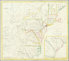
Highly detailed Revolutionary War map of the region between Pennsylvania and northern Florida, produced by the French Admiralty. In addition to the excellent coastal detail and soundings, the map provides excellent detail inland to the Appalachians and extends west to Fort Necessity and the Ohio River in Western Virginia. The map shows early counites and Territitories throughout the region, as well as early roads Indian Tribes, towns, mountains and rivers. The details in Georgia, the Carolinas, Virginia and the Chesapeake are as good as any English maps, other than perhaps the Mouzon and Frye Jefferson. Soundings throughout the Chesapeake. An essential map for Revolutionary War era collections.


![A New Map of Virginia [Chesapeake]](https://storage.googleapis.com/raremaps/img/small/43053.jpg)