|
||

|

|
|

|
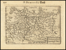
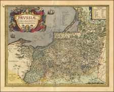
Detailed map of the region bounded by the Baltic Sea and Sinus Finnicus and extending to the Black Sea and the Dniestr River in the south. The map is centered on the Poland, Prussia, the Ukraine, Lithuania, Latvia and Estonia and includes a marvelous look at this constantly changing region. Large decorative cartouche. Too much detail to describe. The map is a genealogical treasure trove, full of long since forgotten city names and spellings. Shows towns, mountains, rivers, lakes, castles and a many long lost geopolitical borders.
Matthäus Seutter (1678-1757) was a prominent German mapmaker in the mid-eighteenth century. Initially apprenticed to a brewer, he trained as an engraver under Johann Baptist Homann in Nuremburg before setting up shop in his native Augsburg. In 1727 he was granted the title Imperial Geographer. His most famous work is Atlas Novus Sive Tabulae Geographicae, published in two volumes ca. 1730, although the majority of his maps are based on earlier work by other cartographers like the Homanns, Delisles, and de Fer.
Alternative spellings: Matthias Seutter, Mathaus Seutter, Matthaeus Seutter, Mattheus Seutter