
The item illustrated and described below is sold, but we
have another example in stock. To view the example which
is currently being offered for sale, click the
"View Details" button below.


|
||

|

|
|

|
Stock# m0053
Description
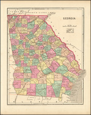
Detailed map, divided by counties and townships. Shows towns, roads, mountains, rivers, railroads, lakes, etc. Morse & Breese's North American Atlas was one of the first American Atlases to employ the cerographic printing process, a process invented by the Morse's and the first truly American printing process. An essential map for American Map collectors, illustrating an important change in the history of printed maps and the only truly American cartographic publishing innovation.

![Dominia Anglorum in America Septentrionali Specialibus Mappis Londini primum a Mollio… [4 maps--New England; Chesapeake, Georgia, Carolinas & Florida; and Nova Scotia…]](https://storage.googleapis.com/raremaps/img/small/60331.jpg)
![(Florida-Georgia) Wie der Franzosen Oberster eine Seul / daran das Wapen dess Königes auss Franckreich / aussrichten lassen. [How the French commander had a seal made, on which the coat of arms of the King of France is displayed.]](https://storage.googleapis.com/raremaps/img/small/95828.jpg)