This item has been sold, but you can enter your email address to be notified if another example becomes available.

Stock# Donation
Description
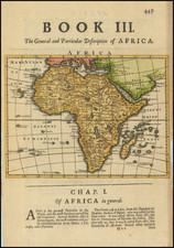
Scarce map of the African Continent, published by Teesdale in London.
The map shows a knowledge of the coastal regions and some interior knowledge, but most of the interior is still largely unexplored.
Henry Teesdale Biography
Teesdale was a London-based map publisher. He was an early Fellow of the Royal Geographical Society, elected in 1830. Teesdale partnered with John Hordan and William Colling Hodson, but this arrangement dissolved in 1832. Afterward, he continued to work on his own and periodically with colleagues like John Crane Dower, Christopher Greenwood, Josiah Henshall and others. He published a variety of atlases and separately-issued maps. His business was quite successful, as he registered as a partner in the Royal Bank of Scotland in 1845.
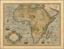
![Totius Africae Accuratissima Tabula Authore I. Danckerts Amsteoldami [Most Accurate Map of All of Africa by I. Danckerts, Amsterdam]](https://storage.googleapis.com/raremaps/img/small/95551.jpg)