|
||

|

|
|

|
Published In Calcutta
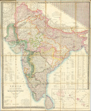
Large detailed map of India, published in Calcutta by the Survey of India in 1883.
This map is a treasure trove of information about early Indian rail development, recording developing infrastructure in what is now India, Pakistan, Bangladesh, Burma, Sri Lanka, and the other surrounding regions. The map includes an inset titled "Continuation of Malay Peninsula and Sumatra on half the Scale", which shows Penang, Malacca, and Singapore, indicated as British colonies.
The map was based on the results of the Great Trigonometric Survey, which started in 1861, in conjunction with more recent Topographical and Revenue Surveys. These were commenced in 1871 under the direction of Colonel H. L. Thuillier, C.S.I-F.R.S., Surveyor General of India. The map was published under the direction of Lieutenant General J.T. Walker, C.B.-R.E.-F.R.S., one of Thullier's successors in the post of Surveyor General of India.
![Carte Particuliere d'une Partie d'Asie ou sont Les Isles D'Andemaon, Ceylan, Les Maldives . . . [with] Partie Occidentale d'une D'Asie ou sont les Isles De Zocotora De l'Amirante . . .](https://storage.googleapis.com/raremaps/img/small/99858.jpg)
![[ India -- With Epitaph Lieutenant Edward Holmes ] To Mark Wood Esq. M.P. Colonel of the Army in India Late Chief Engineer and Surveyor General, Bengal. This Map of India Compiled from various Interesting and Valuable Materials Is Inscribed in grateful Testimonial of his Liberal Communications By his obedient and most humble Servant A. Arrowsmith . . . 1804](https://storage.googleapis.com/raremaps/img/small/99889.jpg)
![[Trekking in the Himalayas]](https://storage.googleapis.com/raremaps/img/small/43997.jpg)