|
||

|

|
|

|
Beautiful Color Mexico City Map
Apogee of Porfiriato Progress and Development
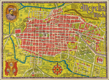
An impressive and attractive color map of Mexico City showing the already significant growth of the city at the start of the 20th-century during the waning days of the Porfiriato and just before the Mexican Revolution. The map is highly detailed, with all major street names, railroads, public works, parks, racetracks, the Zocalo, and the like, indicated. The historical center of the city largely follows the old colonial street grid, first laid out after the arrival of Hernan Cortes in the 1520s. However, we also see the first of the grand European-style boulevards, such as the Paseo de la Reforma, which are now a signature feature of the city. New suburbs or 'colonias' to the west and southwest are shown to be in a state of development, although much of the area surrounding the city proper is still rural and agrarian, as old canals traverse what was a reclaimed lake bed.
The Hipodromo del Jockey Club is shown in what is presently the neighborhood of Hipodromo Condesa, adjacent to Colonia Roma, two areas that were just beginning to be developed at the time of this map - the few scattered lots with buildings shown in brown. Most of the current day street names in Colonia Roma Norte are indicated herein (Colima, Durango, Puebla, Orizaba, Jalapa, Tabasco, etc.), with the obvious exception of Avenida Alvaro Obregón, which is still Avenida Jalisco on this map. The enclave of Romita is shown as a distinct area, a holdout entirely cut-off from the surrounding modernization. Other areas of development west and south of the Centro include Colonia Escandón and Tacubaya, but vast tracts in Mixcoac are still shown as open green space.
In this map the city's limits are shown bounded in the north by Rancho de la Naranja and hacienda de Clavería; in the east, by the suburbs of Nuevo Rastro and Bolsa; in the south, La Piedad River, separating the city from the municipalities of Ixtapalapa and Mixcoac; in the west, Tacubaya, molino de Valdez, Panteón de Dolores, and the ranchos of La Hormiga and Chavito.
The map indicates all rivers, ranchos, haciendas, showing the division of the eight major sections of the city. An explanation of the steam railroad lines appears in the extreme upper right corner. An inset key lists the major public buildings, including churches, theatres, jails, hotels, telegraphs, casinos and markets.
Beautifully printed in color lithography by the Compañía Litográfica, S.A. in Mexico City. Signed in the stone by Guillermo B. Puga, with the following note indicating that the map was published with the authorization of the Director of Public Works:
Este plano se publica con autorización de la Dirección General de Obras Públicas. Guillermo B. Puga.
A wonderfully detailed early 20th-century map of Mexico City at a transitional moment in the city's infrastructural development, before the post-Revolutionary hyper expansion which ushered in the megalopolis we know today.
Rarity
This map is rare in the market, especially in such nice condition. While we have handled a similar map issued in 1900, also by the Compañía Litográfica, this is the first time we have seen the 1907 iteration. OCLC locates only three examples of this 1907 map, those in the Library of Congress (in poor condition), the University of Texas at San Antonio, and El Colegio de Mexico.