|
||

|

|
|

|
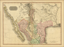
This map of the Republic of Texas, engraved by William Kemble for John Monette's The History of the Discovery and Settlement of the Valley of the Mississippi, captures the configuration of the nascent nation just after its declaration of independence from Mexico. Published in New York by Harper & Brothers in 1846, it offers a detailed cartographic representation of Texas during a pivotal moment in its history.
The year 1836 was a crucial turning point for Texas, marking its transition from a Mexican territory to an independent republic. This period was characterized by significant political and territorial changes, laying the foundation for the state's future. The map's depiction of early colonization grants, settlements, and towns provides a snapshot of Texas at a time of rapid transformation and growth. The delineation of various grants, such as John Cameron's and Stephen H. Austin's, reflects the complex land distribution and colonization efforts that were integral to Texas's development.
William Kemble's skill in engraving this map is evident in its intricate detailing, drawing from sources like Thomas Gamaliel Bradford's 1835 map and Stephen F. Austin's 1830 map. The emphasis on the newly established grants highlights the ongoing negotiations and claims over land that were central to the Republic of Texas's identity.