|
||

|

|
|

|
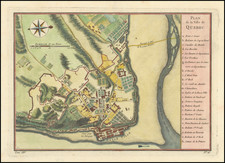
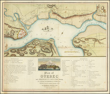
This detailed late 17th-century map captures the English assault on the French-held city of Québec from October 16 to 22, 1690. The map is part of the fifth volume of Les Forces de l'Europe, a collection published between 1693 and 1697, featuring plans of principal cities and their fortifications, designed by the renowned French military engineer Sébastien Le Prestre de Vauban.
The map illustrates the failed English attack on Québec during the Nine Years' War (1688–1697), a conflict that saw France pitted against a coalition including England, Spain, and the Holy Roman Empire. The English fleet is depicted in the Saint Lawrence River, positioned strategically in front of the fortified city of Québec. Despite their efforts, the English forces were repelled by the French defenders under the command of Governor Louis de Buade de Frontenac.
Cartographic Features
- The City of Québec: The map prominently displays the fortified city of Québec, showcasing its defensive structures, including the city walls, batteries, and strategic positions.
- English Fleet: The English naval forces are depicted in formation in the Saint Lawrence River, with their positions and movements marked.
- Surrounding Areas: The map includes detailed illustrations of the surrounding areas, including villages such as Beauport and notable geographic features like the Île d'Orléans and Pointe de Lévy.
- Key Locations and Annotations: The left side of the map features a legend, or "Renvoi des Chiffres," which identifies key locations within the city, such as the citadel, royal battery, and other important military and civic structures.
Nicholas de Fer (1646-1720) was the son of a map seller, Antoine de Fer, and grew to be one of the most well-known mapmakers in France in the seventeenth century. He was apprenticed at twelve years old to Louis Spirinx, an engraver. When his father died in 1673, Nicholas helped his mother run the business until 1687, when he became the sole proprietor.
His earliest known work is a map of the Canal of Languedoc in 1669, while some of his earliest engravings are in the revised edition of Methode pour Apprendre Facilement la Geographie (1685). In 1697, he published his first world atlas. Perhaps his most famous map is his wall map of America, published in 1698, with its celebrated beaver scene (engraved by Hendrick van Loon, designed by Nicolas Guerard). After his death in 1720, the business passed to his sons-in-law, Guillaume Danet and Jacques-Francois Benard.