|
||

|

|
|

|
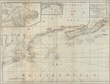
Scarce Colonial Era Sea Chart of New England
Detailed chart of the coastline from Cape Codd to Casco Bay, published in Mount & Page's eponymous Fourth Book, English Pilot, the primary sea atlas used by American and British mariners during the 18th Century.
First issued shortly after the conclusion of the Treaty of Paris of 1763, which ended the French & Indian War, the map was produced as primarily for coastal navigation. The chart offers extensive details on underwater depths, especially in bays and harbors, along with shoals and other maritime hazards. Notably, the top right corner features five profile views, serving as navigational aids for mariners approaching Cape Cod and Maine's southern coast. Despite its practical utility, the chart's representation of coastal geography, particularly of the Boston peninsula and Outer Cape, is somewhat irregular. Coastal towns are depicted in a simplified manner, indicated by small churches and buildings in profile.
The left hand sheet is taken up almost entirely by the Massachusetts Bay extending northwards to Newberry. Various churches and buildings mark the sites of several towns along the coast.
"The English Pilot," initially conceptualized by London publisher John Sellers, aimed to challenge the Dutch dominance in chart publishing. Sellers' first edition in 1671, spanning two volumes, primarily covered European waters, notably deriving much of its content from Dutch charts. Subsequently, John Thornton and William Fisher acquired the Pilot, enhancing and expanding it with new charts, including the Fourth Book in 1689, which focused on the Americas. Over its century-long publication history, this Fourth Book underwent 37 editions. Despite the emergence of more advanced atlases like Sayer and Bennett’s North American Pilot and Des Barres’ Atlantic Neptune, the Fourth Book's strong reputation ensured its continued reissue.
The bibliographic history of "The English Pilot. Fourth Book" is notably intricate. Over its extended publication period, it featured three distinct general charts of New England waters. The dates mentioned are referenced derive from Ashely Baynton-Williams’ "The Charting of New England."
Captain Henry Barnsley (1717-1757), produced several sea charts in the mid 18th Century. Barnsley was part of the force sent by Vice Admiral Francis Holbourne to capture Louisbourg, in command of the HMS Tilbury, a 58-gun fourth rate ship of the line of the Royal Navy. The ship wrecked on a reef (Tilbury Rock) on Cape Breton island Reef near St. Espirit Island on September 24, 1757, where Barnsley was one of 120 crew members who drowned.
This chart was created by Captain Henry Barnsley and was first published in the 1764 edition of The English Pilot, Fourth Book, replacing a chart of the region by Cyprian Southack that extended to Nova Scotia. This chart only appeared in a few editions of The English Pilot, and is thus quite scarce on the market.
![[Portland & Cape Elizabeth to Moskito Island -- Centered on Kennebec River]](https://storage.googleapis.com/raremaps/img/small/50079.jpg)