


|
||

|

|
|

|
Stock# 99717
Description
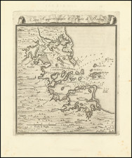
One of the earliest obtainable maps of Boston
Interesting and detailed map of the Port of Boston and Vicinity, published at the conclusion of the French & Indian War.
Includes towns, Islands, soundings, etc.
From the Gazzettiere Americano published in Livorno in 1763, based upon an earlier work by Thomas Jefferys, which did not include any maps.
![[Revolutionary War Plans of New York, Boston, Charleston, Delaware River to Philadelphia & Havana] Various Plans and Draughts of Cities, Towns, Harbours &c . . .](https://storage.googleapis.com/raremaps/img/small/83450.jpg)
![[Boston Harbor and Environs] Coast Chart No. 9 Boston and Approaches . . . Massachusetts Bay with the Coast from Cape Ann to Cape Cod . . . 1872](https://storage.googleapis.com/raremaps/img/small/90721.jpg)
![[ Revolutionary War Boston ] Carte Particuliere Du Havre De Boston . . . 1780](https://storage.googleapis.com/raremaps/img/small/61227.jpg)