


|
||

|

|
|

|
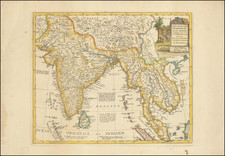
This carefully rendered 1717 map, titled Les Indes Orientales Suivant les Nouvelles Observations de Messrs. de l'Academie Royale des Sciences etc. Augmentees de Nouveau, presents a detailed view of the southern half of the Asian continent, stretching from the Persian Sea to Japan and down to the Indian Ocean. Created by Pieter Van der Aa and published in Leiden, this map was an integral part of Jean Mandelslo's renowned travelogue, Voyage de Perse aux Indes Orientales, and offers a unique blend of geographical accuracy and 17th-century European perspectives on Asia.
The decorative cartouche, adorned with images of an elephant, porcelain, pagodas, and costumed natives, enhances the map's visual appeal and serves as a testament to the European perception of the Far East as a land of wealth and exoticism.
Mandelslo, a German diplomat, embarked on his extensive travels through Russia, Persia, India, Ceylon, and Madagascar in the late 1630s. Although his journey began as a political mission for the Duke of Holstein, it evolved into an adventurous exploration, with Mandelslo later documenting his experiences. This map, therefore, not only represents the geographical knowledge of its time but also complements the narrative of Mandelslo's journey, offering a window into the early European exploration and understanding of the Asian continent.
Pieter van der Aa (1659-1733) was a Dutch mapmaker and publisher who printed pirated editions of foreign bestsellers and illustrated books, but is best known for his voluminous output of maps and atlases. Van der Aa was born to a German stonecutter from Holstein. Interestingly, all three van der Aa sons came to be involved in the printing business. Hildebrand was a copper engraver and Boudewyn was a printer.
![[ India ] Presqu Isle De L'Inde Decale Golfe De Bengala](https://storage.googleapis.com/raremaps/img/small/97365.jpg)