This item has been sold, but you can enter your email address to be notified if another example becomes available.


|
||

|

|
|

|
Stock# 99638
Description
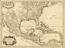
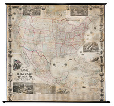
Interesting map of the United States, pre-dating the hard push to extend the Western Territories.
Texas is still part of Mexico and unnamed, as is Upper California. Tanner's Indian Districts are named (Ozark, Osage, Mandan, Sioux, Huron). Ft. Gratio is shown, but Michigan Territory is unnamed. Excellent detail along the Missouri River and in Oregon Territory.
The Rio Caledonia is shown, but not the Fraser. Smith's River is shown, an early reference to Jedidiah Smith, whom the French honored with some landmark in most maps from the late 1830s through the 1850s.
Fascinating early map of the Transmississippi West.
![Colton's United States Shewing Military Stations, Forts &c. . . . 1861 [Shows Colorada!]](https://storage.googleapis.com/raremaps/img/small/95088.jpg)