|
||

|

|
|

|
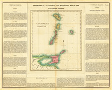
Shipmasters reporting to Hanschell & Co. will oblige by hoisting the above signals on making the Island
Rare pair of maps, with sailing directions on the verso, illustrating the island of Barbados and its capital, Bridgeport.
Valdemar Hanschell, a Danish merchant and sea captain from St. Thomas in the Danish Virgin Islands, established a chandlery business in Barbados in 1884. This business initially supplied ships with essential items such as ropes, sails, and provisions. By the early 20th Century, it was advertising its services as Steamship and Insurance Agents, Charting Brokers and Commission Merchants, with "Ships Stores and Outfits of Every Description Supplied."
As the company grew, it diversified into the local liquor market, launching Cockspur rum, which quickly became the best-selling rum on the island. The company evolved into Hanschell Inniss Ltd., which continues to blend and bottle rum at its operations in Fontabelle, north of Bridgetown. Cockspur rum, produced since 1884 at the famous West India rum factory, is now shipped worldwide. In 1971, Hanschell Inniss Ltd. was formed through the merger of James H. Inniss & Son Ltd. and Hanschell Larsen & Co. Ltd., and was later acquired by J.N. Goddard & Sons Ltd. in 1974.
Rarity
The broadsheet is very rare.
We were unable to locate another example.
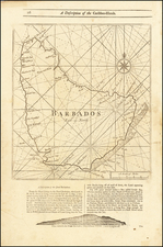
The following is a transcription of the sailing directions:
VESSELS APPROACHING BARBADOS will do well to observe the following sailing directions:
There are three lights on the island, the particulars of which are as follows, viz.
Revolving Light on Ragged Point—This light is exhibited from a lighthouse erected on Ragged Point, a little north of the extreme eastern end of this island, position in Lat. N. 13° 10' Long. W. 59° 30'. It is a revolving holophotal one, elevated 213 feet above the level of highwater, giving flashes at intervals of two minutes, and in clear weather should be seen from a distance of 20 to 23 miles. The lighthouse is situate one yard from the extremity of the cliff, at a distance of two miles and a half northwest from the extreme end of a group of dangerous rocks, called "The Cobbler's Rocks," running parallel with the southeastern coast of the island. It is thirteen miles in a direct line northeastern of the South Point Light.
Mariners are advised to keep well off to the northeast of the lighthouse, to avoid the prevailing strong current running westward on the "Cobblers."
Light on South Point—The Light—a fixed catadioptric, stands a lighthouse 70 feet high, painted with alternately red and white bands, the base being 54 feet above the sea. It is a red light, and revolves once in 1 minute; it is eclipsed for 15 seconds, reappears, and gives two 8 seconds flashes to its greatest brilliancy, and in 42 seconds more is again eclipsed. It is visible 15 miles, but only between the bearings W.S.W. ¼ S. and E.S.E. ¼ E. At South Point, where the rocks terminate, there is a flat spot which must have a berth an one half off shore a mile to the W.S.W.
A careful cross-bearing of Ragged Point and South Point Lights will show how far the vessel is from shore by the angle at the time.
Needham's Point and Light—On Needham's Point, the southern limit of Carlisle Bay, a fixed light is exhibited at the mouth part of Fort Charles. The light shows red from east to west to the southward, and white to the north and west. The White Light is visible 8 or 10 miles and the Red Light 8 miles.
At Red Beacon, Buoy, with staff and vane, placed on the Shoal extending north from Needham Point, is of most advantage on approaching the anchorage. It lies in 5 fathoms, with Garrison clock in line with the north west of Beckwith Fort, bearing E.B.N., and the outer house of Pelican Point N.N.W. Those entering the Buoy will observe to keep it in line with Pelican Isle; and pass it as near as they please hauling up N.N.E., until water deepens to no fathoms, or when the signal post on the hill comes open of the Ordnance Wharf, when the shoal will be cleared.
The masters of vessels arriving for the purpose of trying the market or awaiting orders would do well to bear in mind that the two third part of Carlisle Bay, in a northerly and southerly direction between NEEDHAM'S POINT BUOY and PELICAN REEF, the latter distinguished by a large wooden beacon, is at present (although varying from 9 to 10 fathoms), by running well past this, and to leeward of the shipping in the lower part of the Bay, good bottom will be found at 4 to 5 fathoms.
We refer to amended charts.
![[St. Barths / St. Martin / Anguilla / Antilles ] -- Plans of Ports Surveyed by Captain Edward Barnett R.N. 1846](https://storage.googleapis.com/raremaps/img/small/70950.jpg)

![Martinico [and] Dominica](https://storage.googleapis.com/raremaps/img/small/85250.jpg)