


|
||

|

|
|

|
Published in the Year of Uruguay's Independence
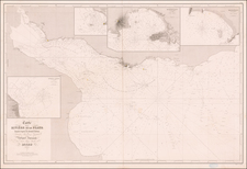
Striking map of the Southern portion of the Continent, from Bolivia to Tierra del Fuego and including Terre De La Trinite.
Shows towns, roads, rivers, lakes, mountains, islands, bays, points, etc. Fascinating hachuring style to represent the various mountains and river valleys. Over a dozen different territories and regions are shown.
In the first 3 decades of the 19th Century, the southern region of South America underwent significant geopolitical changes, marked by the decline of Spanish colonial rule and the emergence of independent nations with new boundaries.
In 1800, Chile was under Spanish colonial administration. The quest for Chilean independence gained momentum with the formation of the First Government Junta on September 18, 1810, an act that signified a move towards autonomy. The ensuing struggle saw figures like Bernardo O'Higgins and José de San Martín at the forefront. The turning point came with the Battle of Chacabuco on February 12, 1817, led by O'Higgins and San Martín, which was instrumental in the formal declaration of Chilean independence on February 12, 1818.
Simultaneously, the region known today as Argentina was part of the Viceroyalty of the Río de la Plata. The May Revolution of 1810 initiated the Argentine War of Independence. This period was marked by internal conflicts and battles against Spanish forces. Leaders like Manuel Belgrano, famous for his role in the Battle of Tucumán in 1812, and José de San Martín, who led the Crossing of the Andes in 1817, played critical roles. Argentina's independence was formally declared on July 9, 1816.
Paraguay, also initially part of the Viceroyalty of the Río de la Plata, declared its independence from Spanish rule on May 14, 1811. This declaration was largely influenced by local leaders such as Fulgencio Yegros and José Gaspar Rodríguez de Francia. Francia's rule, starting from 1814, was characterized by a notable isolationist policy that distinguished Paraguay from its neighbors.
Uruguay's early 19th-century history was shaped by its position as a buffer zone between larger regional powers. The struggle for Uruguayan identity and independence was influenced by conflicts involving Spain, Portugal, and later Brazil. Uruguay's path to independence was formalized with the Treaty of Montevideo, signed on August 27, 1828, which recognized Uruguay as an independent entity.
The boundary disputes between Paraguay and Argentina during this period were complex. The primary contention was over the Paraguay River and adjacent territories. These disputes, originating from unclear colonial territorial delineations, were exacerbated by the rise of independent states and their territorial claims. These disputes continued well into the 19th Century, significantly influencing the political and geographic landscape of the region.
Beginning in the early 19th Century, Lapie was one of the leading French mapmakers, at a time when much of the great exploration and travel literature was being published in French. Lapie was often the engraver of maps which were included in these books. As a result, he often incorporated the most recent information and discoveries in his maps, often appearing prior to the official report from which the information derived. His maps are now prized for their detail, accuracy and attractive engraving style.
![[Magellan's Strait] Exquisita & magno aliquot mensium periculo Lustrata et iam retecta Freti Magellanici Facies . . .](https://storage.googleapis.com/raremaps/img/small/94451.jpg)
![[ Argentina & Uruguay ] La Plata](https://storage.googleapis.com/raremaps/img/small/97143.jpg)