|
||

|

|
|

|
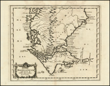
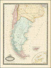
Exploring and Charting Magellan's Straits -- With Charles Darwin
Scarce French Sea chart of the Straits of Magellan, based upon the voyages and explorations of Phillip Parker King and Robert Fitz Roy.
Shows the Straits of Magellan and neighboring sounds, canals, etc. in remarkable detail, including place names, soundings and sailing directions.
The exploratory and surveying endeavors conducted by Phillip Parker King and Robert Fitz Roy in the Straits of Magellan and its surrounding regions between 1826 and 1834 represent a significant epoch in the annals of nautical exploration and scientific discovery. These expeditions, central to the advancement of hydrographic knowledge and natural sciences in the region, played a crucial role in elucidating the complex geography of southern South America.
Phillip Parker King, a distinguished figure in British naval history, was renowned for his prior comprehensive surveys of the Australian coastline. Between 1826 and 1830, King embarked on an ambitious project to chart the southern extremities of South America. His focus on the Straits of Magellan, a labyrinthine passage first navigated by Ferdinand Magellan in the early 16th century, aimed to demystify the notoriously perilous waters of this region. King's meticulous cartography significantly augmented the safety and navigability of these routes, providing invaluable aid to subsequent mariners.
Concurrently, Captain Robert Fitz Roy, commanding the HMS Beagle, undertook a series of surveying missions in this region, particularly between 1831 and 1834. Fitz Roy, later esteemed for his collaboration with Charles Darwin, materially advanced the mapping of the Straits of Magellan and adjacent coastlines. Beyond hydrography, Fitz Roy's contributions to meteorology, including early weather prediction methods, were pioneering for the era.
The intersection of these expeditions in the Straits of Magellan not only marked a leap in hydrographic proficiency but also significantly influenced the scientific realm. The naturalistic observations and specimens collected by Charles Darwin during these voyages laid the groundwork for his evolutionary theories, which radically transformed contemporary understandings of biology.
The Dépôt de la Marine, known more formally as the Dépôt des cartes et plans de la Marine, was the central charting institution of France. The centralization of hydrography in France began in earnest when Jean-Baptiste Colbert became First Minister of France in 1661. Under his watch, the first Royal School of Hydrography began operating, as did the first survey of France’s coasts (1670-1689). In 1680, Colbert consolidated various collections of charts and memoirs into a single assemblage, forming the core of sources for what would become the Dépôt.
The Dépôt itself began as the central deposit of charts for the French Navy. In 1720, the Navy consolidated its collection with those government materials covering the colonies, creating a single large repository of navigation. By 1737, the Dépôt was creating its own original charts and, from 1750, they participated in scientific expeditions to determine the accurate calculation of longitude.
In 1773, the Dépôt received a monopoly over the composition, production, and distribution of navigational materials, solidifying their place as the main producer of geographic knowledge in France. Dépôt-approved charts were distributed to official warehouses in port cities and sold by authorized merchants. The charts were of the highest quality, as many of France’s premier mapmakers worked at the Dépôt in the eighteenth century, including Philippe Bauche, Jacques-Nicolas Bellin, Rigobert Bonne, Jean Nicolas Buache, and Charles-François Beautemps-Beaupré.
The Dépôt continued to operate until 1886, when it became the Naval Hydrographic Service. In 1971, it changed names again, this time to the Naval and Oceanographic Service (SHOM). Although its name has changed, its purpose is largely the same, to provide high quality cartographic and scientific information to the France’s Navy and merchant marine.
![Patagonia [with] South Orkney [with] Falkland Islands [with] South Georgia Island](https://storage.googleapis.com/raremaps/img/small/77042.jpg)