


|
||

|

|
|

|
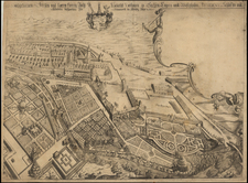
Fine old color example of Blaeu's map of Marquisat Moravia, published in Amsterdam.
The map is centered on Olmutz (Olomouc) and provides a remarkable topographical look at the Marquisate of Moravia.
During the early 17th century, Moravia was under the rule of the Habsburg Monarchy, with key figures such as Emperor Rudolf II and later Ferdinand II. These rulers were instrumental in enforcing the Counter-Reformation, which significantly impacted the religious and cultural landscape of Moravia.
Moravia's geopolitical situation in this period was largely influenced by its position within the Habsburg Monarchy and the broader context of the Thirty Years' War (1618–1648). The war was not only a religious struggle but also a battle for political power, involving major European powers such as the Holy Roman Empire, Spain, France, Sweden, and the Dutch Republic.
Brno and Olomouc were among the most significant cities in Moravia during this period. Brno, the historical capital, was a center of commerce, culture, and governance. It played a crucial role during the Thirty Years' War, especially during the Swedish siege in 1645, where the city's successful defense was a notable event. Olomouc, another key city, was notable for its religious significance and as a center of education and administration.
The Defenestration of Prague in 1618, which marked the beginning of the Thirty Years' War, had significant repercussions in Moravia. The region witnessed several military campaigns and occupations, particularly by Swedish armies.
Willem Janszoon Blaeu (1571-1638) was a prominent Dutch geographer and publisher. Born the son of a herring merchant, Blaeu chose not fish but mathematics and astronomy for his focus. He studied with the famous Danish astronomer Tycho Brahe, with whom he honed his instrument and globe making skills. Blaeu set up shop in Amsterdam, where he sold instruments and globes, published maps, and edited the works of intellectuals like Descartes and Hugo Grotius. In 1635, he released his atlas, Theatrum Orbis Terrarum, sive, Atlas novus.
Willem died in 1638. He had two sons, Cornelis (1610-1648) and Joan (1596-1673). Joan trained as a lawyer, but joined his father’s business rather than practice. After his father’s death, the brothers took over their father’s shop and Joan took on his work as hydrographer to the Dutch East India Company. Later in life, Joan would modify and greatly expand his father’s Atlas novus, eventually releasing his masterpiece, the Atlas maior, between 1662 and 1672.
![[ Holy Roman Empire ] S. Imperium Romano-Germanicum oder Teutschlenad mit Seinen Angrantzenden Konigreichen und Provincien,...](https://storage.googleapis.com/raremaps/img/small/98433.jpg)
![(Second World War - Second Czechoslovak Republic) Malá, ale naša [Small, but ours]](https://storage.googleapis.com/raremaps/img/small/97457mp2.jpg)
![[ Electors of the Holy Roman Empire ] Ordines Sacri Romani Imp: Ab Ottone III Instituti](https://storage.googleapis.com/raremaps/img/small/99053.jpg)