|
||

|

|
|

|
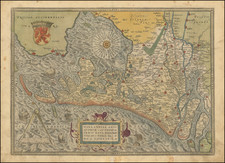
Stunning old color example of Hondius's map of the Duchy of Brabant.
Oriented with west at the top, the map includes two cartouches and a coat of arms.
This exquisitely detailed map shows the Duchy of Brabant, a prominent territorial unit within the Holy Roman Empire and the Low Countries.
Originally a constituent of the Burgundian Netherlands, the Duchy of Brabant became a theater of conflict during the Eighty Years' War (1568–1648), a revolt against Spanish rule. This period saw a relentless struggle for dominance, with pivotal figures such as the Archduke Albert VII of Austria and Isabella Clara Eugenia of Spain, who ruled as sovereigns of the Spanish Netherlands from 1598 to 1621.
Cities such as Brussels, Antwerp, and Leuven were hubs of commerce and culture.
Henricus Hondius (1597-1651) was a Dutch engraver and mapmaker, a member of a prominent cartographic family. His father, Jodocus Hondius, was also an engraver and geographer. While working with his father, Henricus was instrumental in the expansion and republishing of Mercator’s atlas, first published in 1595 and republished by Hondius in 1606.
Upon his father’s death in 1612, Henricus and his brother, Jodocus the Younger, took over the business. He set up his own shop in 1621, where he continued to release new editions of the Mercator atlas. Later, he partnered with his brother-in-law, Jan Janssonius, in continuing to expand and publish Mercator’s atlas, which would become known as the Mercator-Hondius-Janssonius atlas. Born and based in Amsterdam, he died there in 1651.
![[ Roman Gaul ] Gallia Antiqua ex Aevi Romani Monumentis Eruta Et Sermi. Carnutum Ducis Munifentia Publici Juris Facta Acutor D'Anville . . . MDCCLX](https://storage.googleapis.com/raremaps/img/small/103405.jpg)
![Sneecha. . . [and] Doccum. [and] Sloten [and] Ylstae](https://storage.googleapis.com/raremaps/img/small/89300.jpg)