|
||

|

|
|

|
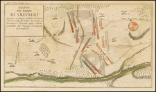
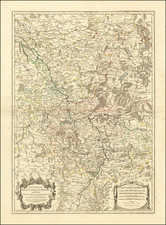
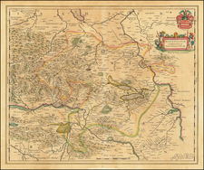
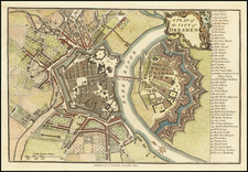
Fossa Eugeniana -- An Early 17th Century Attempt To Circumvent The Dutch Blockades by Canal During the 80 Years War
Fine old color example of the first state of Blaeu's map of the Fossa Eugeniana, an early canal which was intended to connect the Maas River (at Venlo) with the Rhine River at Rhineberg.
The map first appeared in Blaeu's Appendix in 1630. The map final state of the map is revised with a large cartouche around the scale of miles (Keuning, Imago Mundi XIV, pp 74-89).
The Fossa Eugeniana, an ambitious canal project, conceived in 1626 under the auspices of the Spanish Netherlands, then governed by the Cardinal-Infante Ferdinand of Spain, a key figure in the Habsburg monarchy. The primary impetus for this project was the strategic necessity imposed by the Eighty Years' War (1568–1648), specifically the need to create a navigable link between the Rhine and Meuse rivers.
The historical backdrop of the Fossa Eugeniana is deeply interwoven with the broader context of the European wars of religion, especially the conflict between the Habsburgs and the Dutch Republic. In the early 17th century, the Spanish Netherlands found itself in a protracted struggle against the burgeoning independence movement of the Dutch. The blockade of the River Scheldt by Dutch forces significantly hampered Spanish control over vital trade and military routes. In response, the construction of the canal was envisioned as a strategic bypass, facilitating the movement of troops and resources, thereby circumventing Dutch-controlled territories.
Initiated in 1626, the construction of the Fossa Eugeniana was a remarkable engineering feat for its time. The route was planned to extend from Rheinberg on the Rhine to Venlo on the Meuse, covering a distance of approximately 50 kilometers. Despite the considerable efforts, the Fossa Eugeniana remained incomplete. By 1629, the project was abandoned and never completed.
Willem Janszoon Blaeu (1571-1638) was a prominent Dutch geographer and publisher. Born the son of a herring merchant, Blaeu chose not fish but mathematics and astronomy for his focus. He studied with the famous Danish astronomer Tycho Brahe, with whom he honed his instrument and globe making skills. Blaeu set up shop in Amsterdam, where he sold instruments and globes, published maps, and edited the works of intellectuals like Descartes and Hugo Grotius. In 1635, he released his atlas, Theatrum Orbis Terrarum, sive, Atlas novus.
Willem died in 1638. He had two sons, Cornelis (1610-1648) and Joan (1596-1673). Joan trained as a lawyer, but joined his father’s business rather than practice. After his father’s death, the brothers took over their father’s shop and Joan took on his work as hydrographer to the Dutch East India Company. Later in life, Joan would modify and greatly expand his father’s Atlas novus, eventually releasing his masterpiece, the Atlas maior, between 1662 and 1672.
![Hennebergensis Ditionis vera delineatio . . . 1594 [and] Hassiae Descriptio . . .](https://storage.googleapis.com/raremaps/img/small/83926.jpg)