


|
||

|

|
|

|
Cold War Era Middle East
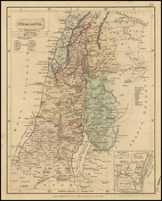
A fine map illustrating the modern divisions of the Holy Land. Published in 1963, this chart seems to reflect contemporary Western sentiments on the Middle East and Holy Land. This is most reflected in the depiction of the polities that make up the region such as Israel, the United Arab Republic, and Syria. The demilitarized and "no man's land" buffer areas of the region are all illustrated which shows the continued tensions in the region during the 1960s. The perceived tensions are further shown in the upper inset which illustrates the southern U.S.S.R. encroaching in the region.
The map places a heavy emphasis on Biblical excerpts that discuss a specific region in Jerusalem, Israel, or the wider Holy Land. Locations such as the Stations of the Cross, the historic seat of King Saul, and key locations in the life of Jesus are noted with a brief text description. These write-ups usually include a Biblical quotation to further legitimize the location of these events.
Overall, a detailed chart of the Holy Land as it appeared in the early 1960s. The significant level of cartographic and historical detail in this chart showcases the growing interest of the Middle East in this period.
![(Czech Edition) Tabule a wymalovánj země Swaté [Map of the Holy Land]](https://storage.googleapis.com/raremaps/img/small/93473.jpg)
![Paradise or the Garden of Eden With the Countries circumjacent Inhabited by the Patriarchs [shows Cyprus]](https://storage.googleapis.com/raremaps/img/small/84459.jpg)