|
||

|

|
|

|
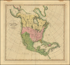
Illustrating The Northwest Passage and Color Coding The Ocean's Currents
Fine large format map of North America, which appeared in Andriveau-Gougon's Atlas Choix.
The map emphasizes and color codes the ocean currents, including the Gulf Stream and currents in the Gulf and the Pacific, using a three color pallet for overlapping currents.
Very unusual treatment of the Transmississippi West, including a misshaped Texas, Ozark District, Mandan District, Osage District, Massive Nebraska Territory. Early prinitimve attempt to depict Oregon Territiory, and a host of other fascination details. Pre-Gadsden Purchase border with Mexico.
Includes a large inset map of western Alaska and Aleutian Islands, while the lands were still Russian.
Elegant depiction of the ocean's currents. Marvelous Indian detail.
A highly detailed and scarce map.


![L'Amerique Septentrionale Divisée en ses Principaux Etats [Sea of the West]](https://storage.googleapis.com/raremaps/img/small/99018.jpg)