


|
||

|

|
|

|
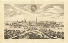
Rare 1807 folding map of Skaraborgs region of Southwestern Sweden, immediately north of Gotthenburg.
The map shows administrative divisions; lakes and other bodies of water shown by hachures.
The map is part of a landmark set of modern maps created by Samuel Gustaf Hermelin, in this instance, with the assistance of local mapmaker Carl Gustaf Forssell, who was born in Skaraborgs, but rose to prominance as a major Swedish mapmaker.
Samuel Gustaf Hermelin was a Swedish industrialist, diplomat, and mapmaker. He was part of the Swedish nobility.
Hermelin was born on April 4, 1744, in Stockholm, Sweden, and died there on March 4, 1820. He was the son of Carl Hermelin, a member of the council of state, and Hedvig Ulrika Benzelstierna. He was educated at Uppsala University, starting September 27, 1760, and later worked in various positions related to mining and chemistry. Hermelin married twice: first to Maria Elisabet Sandels in 1773, who died in 1779, and then to Hedvig Augusta af Söderling in 1785, who died in 1794.
By the age of 17, Hermelin had completed the necessary studies to enter the mining college, where he began as an observer in 1761. He deepened his knowledge in the laboratory and spent years conducting geological field studies and metallurgical experiments. In 1764, he experimented with copper smelting at Åtvidaberg and later, with coal minerals in Skåne. He traveled to Norway in 1768 to study its geology and mining industries. Hermelin received a scholarship in 1769 to visit Sweden's mining sites, focusing on the quality of copper and introducing new methods to improve it. In the 1770s, he became a partner in an industry processing pyrite from mines.
In 1782, King Gustav III sent him to North America to study geology and promote Swedish trade interests. Despite carrying a ministerial letter, his mission remained discreet due to Sweden's relations with England. Hermelin was well-received in America, inducted into the Cincinnatus Order, and extended his stay due to illness. His return trip included studies in Germany, the Netherlands, France, and England.
Hermelin opposed the absolute monarchy in Sweden and was involved in the political opposition. He was questioned for his potential involvement in the 1792 assassination of Gustav III but denied all connections and allegedly avoided trial by bribing a police chief.
Hermelin was instrumental in promoting the use of Sweden's natural resources, leading to his extensive travels and the production of geographical maps. The Hermelin atlas, published from 1796 to 1818, marked a significant phase in Swedish cartography, although Hermelin faced financial losses from this project.
Later, he attempted to develop the iron industry in Norrbotten but faced several setbacks, including natural disasters and the war of 1809, which ultimately led to his bankruptcy in 1812. Despite this, the Swedish parliament granted him an annual pension for his geographical contributions from 1818.
In 1784, Hermelin became a Foreign Honorary Member of the American Academy of Arts and Sciences. He also joined the American Philosophical Society in Philadelphia as an international member in 1785.
Carl Gustaf Forsell, initially Carl Gustaf Forssell, was born on March 18, 1783, at Sköttorp, in the Järpås parish of Skaraborg, Sweden. He died on October 25, 1848, in Stockholm. His parents were Captain Fredric Joseph Forsell and Maria Dorothea de Bruce.
He started his military education as a cadet at the Karlberg military academy from February 6, 1796, to September 30, 1800. He then became a midshipman in the navy on October 20, 1800, and a junior lieutenant in the field survey corps on November 18, 1806. Forsell climbed the ranks, becoming a captain in the army by June 29, 1809, and later, a major.
Forsell worked on several cartography projects, contributing to the mapping of Sweden’s coastlines and landscapes. His military service included participating in the 1798 naval expedition on the frigate Ulla Fersen and contributing to the early surveys for the Göta Canal between 1808 and 1809. In the early years, he was commanded to map the Bohuslän archipelago and later, between 1804 and 1808, funded by Bergsrådet S.G. Hermelin, he traveled and created maps of Bohuslän, Halland, Västergötland, Småland, and Blekinge, contributing significantly to the geographical documentation of Sweden.
He was ennobled on February 11, 1817, and continued to serve in various capacities, including as the Director-General of the Swedish Land Survey from January 29, 1824. He also attained the rank of colonel in the army on June 3 of an unspecified year.
On September 3, 1818, Forsell married Clementina Magdalena Geijer, the daughter of Salomon Eberhard Geijer and Ulrica Charlotta Zidén, and widow of Johan Daniel Psilander.
Apart from his military and surveying work, Forsell was involved in public service and civic initiatives. He contributed to the early development of Sweden's transportation infrastructure and public banking. He was also recognized with several Swedish and foreign orders for his service and achievements.
Forsell's contributions extended to societal reforms, including support for the temperance movement and educational initiatives. He lived in Stockholm, where he was active in various community and national projects until his death in 1848. His life and work were documented in detail by his daughter Marie-Louise af Forsell in her extensive diaries.
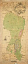
![[ Halmstads Chiefdom, Southwestern Sweden ] Karta öfver Halmstads Höfdingedöme eller Halland Utfivven Af Frieherre S.G. Hermelin Författad . . . . af Carl G. Forssell. 1807](https://storage.googleapis.com/raremaps/img/small/99085.jpg)