


|
||

|

|
|

|
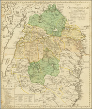
Impressive early-19th-century map of the area around Karlstad and the larger region of Värmland in Sweden. The title translates to "Map over Karlstad's Chieftainship or Värmland Published by Baron S.G. Hermelin After New Astronomical Observations and Summary of Geometrical Measurements."
This map was created by Samuel Gustaf Hermelin, a Swedish baron, geographer, and mining expert who lived between 1744 and 1820. Hermelin was a significant figure in the development of Swedish cartography and mining, and he was known for his efforts in improving the accuracy of maps through the use of astronomical observations and geometrical measurements.
The map itself shows detailed geographical features of Värmland, a historical and geographical region in west-central Sweden, with an emphasis on accuracy and detail that was groundbreaking for its time. The maps emphasis is on the many lakes and rivers of the region, and its human habitation; the map includes much in the way of building-level detail.
Key
The following is a translation of the detailed key:
- Kyrkor: Churches. This would denote the location of churches on the map.
- Säterier: Manors. A term for a type of large estate or manor, often associated with the nobility.
- Bebygda Gårdar: Inhabited farms. This likely indicates the farms that were inhabited or in active use.
- Stångjärnshamrar: Bar iron hammers. Refers to workshops or small factories where bar iron was produced or refined.
- A Manufacturhamrar: Manufacture hammers. This could refer to hammers used in manufacturing processes, possibly in workshops producing goods other than iron.
- Masugnar: Blast furnaces. Places where iron ore was smelted to produce iron.
- Prestgårdar: Vicarages or rectories. The residences of priests or ministers.
- Gåstgivaregårdar: Inns. These provided lodging and food for travelers.
- Kungsvågar: Royal scales. Weighing stations that were probably under royal charter or control, used for weighing goods for trade or taxation purposes.
- Landsvågar: Provincial scales. Similar to Kungsvågar but operated at a provincial level.
- Hårads och Socknevågar: District and parish scales. Weighing stations at the district (härad) and parish (socken) levels.
- Karr och Ridvågar: Cart and rid scales. These terms are less clear but could refer to specific types of scales used for weighing carts (loaded vehicles) and possibly rid refers to some form of standardized weight or measurement.
- Bergstullar: Mining tolls. Locations where taxes or tolls were collected, likely on goods being transported from mines.
Samuel Gustaf Hermelin was a Swedish industrialist, diplomat, and mapmaker. He was part of the Swedish nobility.
Hermelin was born on April 4, 1744, in Stockholm, Sweden, and died there on March 4, 1820. He was the son of Carl Hermelin, a member of the council of state, and Hedvig Ulrika Benzelstierna. He was educated at Uppsala University, starting September 27, 1760, and later worked in various positions related to mining and chemistry. Hermelin married twice: first to Maria Elisabet Sandels in 1773, who died in 1779, and then to Hedvig Augusta af Söderling in 1785, who died in 1794.
By the age of 17, Hermelin had completed the necessary studies to enter the mining college, where he began as an observer in 1761. He deepened his knowledge in the laboratory and spent years conducting geological field studies and metallurgical experiments. In 1764, he experimented with copper smelting at Åtvidaberg and later, with coal minerals in Skåne. He traveled to Norway in 1768 to study its geology and mining industries. Hermelin received a scholarship in 1769 to visit Sweden's mining sites, focusing on the quality of copper and introducing new methods to improve it. In the 1770s, he became a partner in an industry processing pyrite from mines.
In 1782, King Gustav III sent him to North America to study geology and promote Swedish trade interests. Despite carrying a ministerial letter, his mission remained discreet due to Sweden's relations with England. Hermelin was well-received in America, inducted into the Cincinnatus Order, and extended his stay due to illness. His return trip included studies in Germany, the Netherlands, France, and England.
Hermelin opposed the absolute monarchy in Sweden and was involved in the political opposition. He was questioned for his potential involvement in the 1792 assassination of Gustav III but denied all connections and allegedly avoided trial by bribing a police chief.
Hermelin was instrumental in promoting the use of Sweden's natural resources, leading to his extensive travels and the production of geographical maps. The Hermelin atlas, published from 1796 to 1818, marked a significant phase in Swedish cartography, although Hermelin faced financial losses from this project.
Later, he attempted to develop the iron industry in Norrbotten but faced several setbacks, including natural disasters and the war of 1809, which ultimately led to his bankruptcy in 1812. Despite this, the Swedish parliament granted him an annual pension for his geographical contributions from 1818.
In 1784, Hermelin became a Foreign Honorary Member of the American Academy of Arts and Sciences. He also joined the American Philosophical Society in Philadelphia as an international member in 1785.
![[ Siege of Stralsunds in 1715 ] Charta öfver Stralsunds Belägring af den Allierade Danske, Preusske, och Sachsiske arméen à: 1715 . . . .](https://storage.googleapis.com/raremaps/img/small/101642.jpg)
![[Denmark and southern Sweden]](https://storage.googleapis.com/raremaps/img/small/75156.jpg)