|
||

|

|
|

|
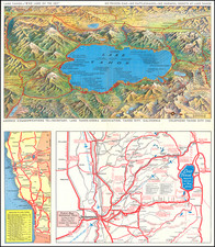
Two sided map and park guide, giving information about Anza-Borrego Desert State Park, in Southeastern California.
Created around 1965, this map served as a guide for visitors, showcasing the park’s myriad recreational opportunities and sightseeing locales. The map itself, rendered in a monochromatic palette, is centered on a detailed illustration of the park’s geography, with specific areas and points of interest clearly marked to facilitate navigation and exploration.
Additional features on the map likely included photographs capturing the park’s natural beauty, from its vast, open desert spaces to its rugged mountain terrains. Descriptions accompanying these images would have provided context and information, enriching the visitor experience by detailing the flora, fauna, and geological features unique to the Anza-Borrego desert environment.
The map also notes recreational amenities available at the time, such as trails for hiking and horseback riding, campsites, picnic areas, and scenic overlooks, each marked with symbols explained in the map's legend. These symbols and a corresponding legend would guide visitors to the park's many natural wonders, including cacti-strewn landscapes, blooming wildflowers, and hidden oases.

![[Austins Colony] Mexico & Guatemala](https://storage.googleapis.com/raremaps/img/small/94054.jpg)
![[Orange County Ranchos -- Signed by Orange County Surveyor]](https://storage.googleapis.com/raremaps/img/small/92333.jpg)