|
||

|

|
|

|
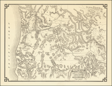
Rare early automobile tourist map of the Klamath Falls area, published by the White Pelican Hotel and White Pelican Garage.
This circa 1920 automobile road map offers a glimpse into the early days of motor travel, serving as a navigational guide for the southern Oregon and northern California regions. It is a testament to the burgeoning era of the automobile, highlighting key routes, landmarks, and services essential for the intrepid motorist.
The map prominently features the White Pelican Hotel and the White Pelican Garage in Klamath Falls, Oregon. Lakeview Garage in Lakeview, Oregon, is also mentioned, indicating its importance as a service point for automobiles during travels in the region.
Geographically, the map outlines several counties—Douglas, Lane, Jackson, Crook, Lake, Klamath, Siskiyou, Modoc, croos and Harvey—providing a network of routes that connect various towns and natural landmarks. It shows a landscape transitioning from the reliance on railroads to roads that accommodate automobiles. The map delineates rivers, lakes, and mountain ranges, essential for orientation in an era prior to electronic navigation aids.
This road map represents an important historical artifact, illustrating the state of overland travel in the Pacific Northwest at the time and offering insight into the services and infrastructures that supported early 20th-century road trips.
Construction on the White Pelican Hotel began in 1911. The White Pelican Hotel and White Pelican Garage briefly ran advertising together in local newspapers in 1915.
Rarity
OCLC locates a single example at the University of Oregon Library

![[Washington & Oregon] Amer. Sep. No. 38. Partie Des Etats-Unis](https://storage.googleapis.com/raremaps/img/small/93549.jpg)

![[Oregon Territory] Carte de l'Oregon (and) [Astoria Factory]](https://storage.googleapis.com/raremaps/img/small/77722.jpg)