


|
||

|

|
|

|
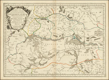
Reclaiming The Lowlands of the Warta River -- Including Dutch Polders!
Rare map of the lower part of the Warta River in western Poland oriented with south at the top, flowing the area near Santok to the confluence of the the Warta and the Oder Rivers near Kostrzyn nad Odrą on the Polish-German border.
The map covers a stretch of roughly 35 miles, with a detailed portrayal of the Warta River and its surrounding areas, detailing the course of the river as it meanders through various settlements, embankments, and the intricate network of canals and ditches. A number of Canals and neighboring roads are shown, along with cadastral informaiton regarding local owners.
At the center of the map is an area shown as "Kongl Genninsche Hollander," which likely refers to the "Königlich Generalinspektion der Holländereien," which translates to the "Royal General Inspection of Hollanders." "Holländer" is a historical term used in German-speaking regions to denote Dutch farmers and agricultural experts, who were renowned for their water management and land reclamation techniques.
In the context of the map and the time period, this would refer to areas managed by Dutch agriculturalists who were commissioned by the Prussian monarchy to drain marshes, swamps, or wetlands ("Bruch" in German) and convert them into arable land or to manage the waterways effectively. The "Hollander" method often involved creating a network of canals, ditches, and embankments to control water levels, both for the prevention of flooding and for the purposes of irrigation.
Polder System Comes To The Warta River
The polder system, a Dutch invention for land reclamation and water management, was employed in the region around the Warta River in the late 18th and early 19th centuries. This system involves the creation of polders, tracts of land enclosed by dikes, where water is managed through a series of canals, pumps, and locks. In the context of the Warta River, the polder system would have been used to reclaim land from marshes and swamps for agriculture and settlement, particularly as part of broader Prussian efforts to develop and control the region. Dutch experts, renowned for their water management skills, were often called upon to design and supervise these reclamation projects, bringing their valuable expertise to the Prussian territories. Their knowledge was especially critical in managing the low-lying, water-abundant landscapes along the Warta, thus shaping the region's hydrological infrastructure and contributing to its agricultural productivity.
Rarity
The map is extremely rare.
We note an example in the Bavarian State Library and an example in the Universitäts- und Landesbibliothek Münster.
![Moscovia Parte Orientale . . . [with] Parte Occidentale . . .](https://storage.googleapis.com/raremaps/img/small/26615.jpg)