|
||

|

|
|

|
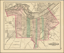
Showing the First Home of the Louisville Grays Baseball Team -- The First Professional Baseball Team
Detailed map of Louisville, Kentucky, printed and published by Brewer's Printing House in Louisville.
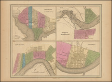
Detailed map of Louisville and neighboring Jeffersonville and New Albany across the Ohio River.
The map emphasizes the Street Railroads and Steam Railroads operating with the city, each of which is illustrated in red. Factories, Distilleries, Fire Stations, Foundries, Mills, Kilns, Quaries, Libraries, Stockyards, Commercial buildings, convents and churches are shown in Black. Along the outer parts of the city, the names of larger landowners are also noted, as is the Crescent Hill Reservoir.
Two other features shown in red are the New Custom House, Union Depot and Base Ball Park.
The map also shows several early Jewish Synagogues.
Louisville Baseball Park / Eclipse Park I -- Home of the Louisville Grays
The Baseball Park shown on the map is the home field of America's first professional baseball team, the Louisville Grays. A charter member of the original National League in 1876, the team was involved in a betting scandal in 1877 was was disbanded in 1878.
The Louisville Baseball Park (also known as Eclipse Park I, which was built in 1877, and became home to the Louisville Grays, the city's first professional baseball team. It was located at the corner of 28th and Broadway. It was used until 1882, when it was replaced by Eclipse Park II, which served as the home for the Louisville Eclipse/Colonels.
The new park was located at the corner of 7th Street and Kentucky Street.
House Refuge Grounds
The map shows the original site of House Refuge Grounds. In 1850, the city of Louisville purchased 80 acres south of the city, now 3rd Street and Eastern Parkway, for a public cemetery. Few people were willing to purchase lots and few burials were performed, so the property was turned over to House of Refuge for a children’s reform school. This property would eventually become the Belknap Campus of the University of Louisville.
Dating The Map
While the example listed by the University of Chicago has been dated 1886, we believe the map is much earlier, as it shows only the Base Ball Park at 28th and Broadway, which was in use from 1877 to about 1882.
Brewer's Printing House was established in Louisville in 1877 at 80 Fifth Street (Seymour Times, October 27, 1877) and had been advertising at its current address by November 1882.
Rarity
The map is very rare. OCLC locates one example (University of Chicago).