|
||

|

|
|

|
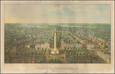
Bachman's Panorama of the Chesapeake Region
Striking combination map and view of the northernmost part of the east coast of the Confederacy, and the southernmost areas of the Union, including Washington: this third issue, printed after the smoke that was added to Manassas for the second issue had been removed again, has "many towns and battlefields ... added, especially around Richmond, Petersburg, and Fredericksburg" (Rumsey). It was published by Charles Magnus of New York.
'At the outset of the Civil War, John Bachmann, of New York City, one of the finest American artists and lithographers specializing in bird's-eye views, began producing a series of panoramas of likely theaters of War' (Stephenson & McKee Virginia in Maps p.239). This view, taken from the apparent vantage point some miles up in the outer atmosphere, was designed to serve as an individual stand-alone image (as here), but also to join with two other views by Bachmann which together form one continuous panorama of the east coast of the Confederacy. In all, Bachmann published six views covering the whole 'Seat of the War'. The present image covers an area that includes the locations of a number of well-known Civil War actions: Harper's Ferry, Fredericksburg, Chancellorsville, Spotsylvania, Manassas, Petersburg, Appomattox River, Richmond, and environs.
John Bachmann was one of America's leading viewmakers, having been responsible for some of the finest New York City views. This innovative cross between view and map appears to have been his own invention, and it gives an intriguing and different perspective on the conflict.
States of the Map
The map is known in 3 states.
- State 1: 1861
- State 2: Smoke billowing up from Manassas in reference to the Battle of Bull Run
- State 3: Published by Charles Magnus in 1864, the battlefield smoke having been removed.
![[Battle of Yorktown] Plan D'York en Virginie avec les attaques et les Campemens de l'Armee combinee de France et d'Amerique](https://storage.googleapis.com/raremaps/img/small/102603.jpg)
![[ Mount Vernon ] The Kitchen Garden of Mount Vernon, Seat of General George Washington in Viginia, The Design of an Elegant Kitchen and Fruit Garden Containing 0.92 Acres](https://storage.googleapis.com/raremaps/img/small/101604.jpg)