|
||

|

|
|

|
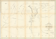
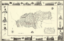
Rare Early Map of Denver
Highly detailed map of the city of Denver, published by H.L. Thayer.
The map is centered on the Platte River and includes the names of dozens of land owners, subdivisions and other details.
In east Denver, the location of a number of buildings are shown with the location of the Denver and New Orleans RR Company Lands just across Cherry Creek in west Denver.
The Platte Water Company's Irrigating Canal is shown in the eastern part of the city, flowing through City Park (Lot 36).
The map is embellished with 6 vignettes, including:
- The National Mining and Industrial Exposition Building (opened August 1, 1882)
- Windsor Hotel
- St. James Hotel
- Daniels & Fisher Bldg
- Court House
- School House
Rarity
The map is very rare. We locate only the example offered at auction by Swann Galleries in 1990.
We offered an example for sale in 2017. In 2012, Cohen & Taliaferro offered Thayer's 1872 map of Denver for $12,000 (Catalog 3, Item 49).
![[Denver] Rollandet's Map of the City of Denver Colorado -- Fourth Edition-- February 1st, 1889](https://storage.googleapis.com/raremaps/img/small/67697.jpg)