|
||

|

|
|

|
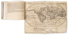
An Incomparable, Unique Spanish Mystery Map of the Pacific Northwest.
Spanish Military Cartographers Record Russian and English Perspectives on Fur Trading in the North Pacific at the End of the 18th Century.
This elaborate manuscript map is an astounding Spanish cartographic palimpsest of speculative Buache-Delisle geography, Russian fur trading information, and data from Captain Cook's third and final voyage. Bearing the signatures of Spanish Engineers Pedro Giraldo de Chaves and Eustoquio Xavier Sedano, the map was likely drawn in the 1780s or '90s. A product of the Spanish Enlightenment period, the map reflects Spain's vigilance over their centuries-old territorial claims to the Pacific Northwest, tracking as rival powers encroached upon the fur-rich lands of the region.
The map was produced following several exploratory expeditions by Spain to the Pacific Northwest, mapping the West Coast of North America and interacting with Russian settlements and explorers in the region, as a means of re-affirming and asserting Spanish claims to the region. This map bears witness to these tensions, portraying the Spanish Empire's efforts to navigate a period of uncertain sovereignty and assert its presence in global trade networks.
The map records speculation about the sources of the Mississippi and Missouri Rivers, presaging important American overland explorations, such as Lewis & Clark and Pike, that would follow at the beginning of the next century.
The title indicates that this is a geo-hydrographical map facilitating the trade in furs and navigation along the coasts of North America, created by order of the Chancellery (i.e., Department) of Commerce in St. Petersburg, Russia. When the flap is laid down, it changes the last part of the title to indicate that the information comes from the Board of Trade in London.
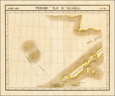
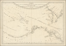
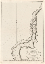
The map extends from Monterey in Nueva California in the south to well into the Arctic Circle. In the west, it shows Kamchatka, "Ysla de la Compania" (a name applied to various real and imagined islands in the north Pacific, but here seemingly associated with Sakhalin Island), and far eastern Siberia.
Cartography of the Pacific Northwest
The cartography of the Pacific Northwest is derived from the so-called Buache-Delisle maps of the 1750s, which they advanced in such works as the Considerations Geographiques, Observations et Cartes Geographiques Concernant les Terres au Nord de la Mer du Sud, Explication de la Carte des Nouvelles Decouvertes Au Nord de la Mer du Sud, and Nouvelles Cartes des Decouvertes de L'Amiral de Fonte. One of the most famous elements of these maps was the "Mer de l'Ouest" or "Sea of the West," a large, hypothesized inland sea in the western part of North America. This mythical sea was believed to be connected to the Pacific Ocean, potentially offering a navigable northwest passage. The maps were also characterized by an archipelagic Alaska.
The Russian and English sections of this map primarily diverge in their depictions of forts and fur-trading establishments, in the inclusion or not of a large River of the West-type system north of the Sea of the West (not included in the English version), and on some other more minor points.
Cook Information but Not Cartography?
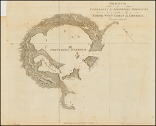
The map includes information derived from the third voyage of Captain James Cook, but seemingly pre-dates the dissemination of the maps from the official account of the third voyage. For example, on the English map panel, there are two notes "En las Cartas Inglesas solo se notas Costas" (In the English charts, only the coasts are noted) and "Ningana Carta Descripcion ni Relacion de los Yngleses se halla el Detalle de lo interior de este Pais y tiene poca confianza de las Relaciones de los Estrangenos." (No map, description, or account by the English provides detail of the interior of this country, and there is little confidence in the accounts of foreigners). These notes, along with the collection of Cook toponyms (Rio de Cook, Ysla Kaye, Bahia del Principe Guillermo, Bahia de Northon, Cabo del Principe de Galles, etc.) invite the questions of what English maps Chaves and Sedano were looking at and when they were looking at them.
Although the map has plenty of Cook toponyms, it reflects no familiarity with the 1784 Faden-Roberts chart, the first printed map to depict the cartography of the third voyage. Additionally, the Faden-Roberts shows details of the interior in the form of the discoveries of Samuel Hearn in the Canadian Arctic--details that Chaves and Sedano say are lacking from all English maps and documents.
Dating the Map
The aforementioned contradiction can be resolved if the map was created between 1781, when the first unofficial textual accounts of Cook's third voyage appeared, and 1784, when the maps of the voyage began circulating widely in Europe in print form. This would explain why Chaves and Sendano knew of some of Cook's discoveries but could not place them accurately.
When Sotheby's sold this map in 1984, they ascribed a date of circa 1790. Later that year, the map was offered by Arader in his Catalog 49, dated circa 1795. In neither case is there an exposition on how the map was dated; nonetheless, we find both dates plausible.
If it was indeed made in the early 1790s, the chart was almost certainly prepared as a kind of retrospective assessment of fur trading in the Northwest as part of Spain's attempts to resolve the Nootka Sound Controversy.
The Nootka Sound Controversy, also known as the Spanish Armament, was a pivotal moment in late 18th-century geopolitics, involving Spain, Britain, and their respective allies. It stemmed from Spain's assertion of its historical rights over the Pacific Northwest, a claim originating from the 1494 Treaty of Tordesillas and reinforced by centuries of exploration, including Balboa's 1513 Pacific sighting. In 1789, at the Spanish outpost Santa Cruz de Nuca, commander Jose Esteban Martínez seized British vessels involved in the fur trade, intending to enforce Spain's monopoly over the region and its trade routes. This action sparked a significant outcry in Britain, almost leading to war. The crisis was defused through the Nootka Conventions (1790–95), which resulted in Spain renouncing many of its exclusive trade rights and territorial claims in the area, effectively ending its 200-year monopoly on Asian-Pacific trade. The resolutions of this controversy signified a major shift in colonial and trade dynamics in the Pacific, marking a decline in Spanish influence and a rise in British mercantile interests.
The map is closely related to one held by the Danish National Library, which also bears the signatures of Chaves and Sedano.
Provenance
- Sotheby Atlases, Maps and Printed Books, 21 May 1984, lot 462, £11,550; Robinson
- W. Graham Arader III, Catalog 49, Summer 1984, Item 6 ("This must be one of the most remarkable maps relating to the Pacific Northwest ever made."), $30,000
- Private American collection