


|
||

|

|
|

|
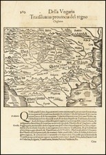
A handsome example of Francesco Berlinghieri's map of southeastern Europe, focusing on the Sea of Marmara and Bosphorus, present-day Bulgaria, Romania, Macedonia, Albania, and Serbia, issued in famed 1482 Septe Giornate della Geographia di Francesco Berlinghieri. This is the third printed map of the region, following those in the 1477 Bologna Ptolemy and the 1478 Rome Ptolemy.
The primary focus of the map is on the watershed of the Danube River; in the lower left is the Ionian Sea; in the lower right the Sea of Marmara and Istanbul ("Gostantinopoli"); the Black Sea dominates the east of the map; the southern extent of the Carpathian Mountains form the northern edge.
Ancient Regions Covered in the Map
Ptolemy's ninth map of Europe covers its southeastern corner, with numerous placenames and regions dating to classical antiquity.
Dacia, once rich in gold and silver mines, encompassed parts of modern-day Romania and Moldova and became a Roman province after its conquest in 106 AD. Adjacent to this, Pannonia Inferiore was another Roman province located in western Hungary and parts of neighboring countries, known for being part of the larger Pannonia region. The Iazyges, a Sarmatian tribe famous for their cavalry, settled in what is now modern-day Hungary. Meanwhile, Thracia, or Thrace, spanned areas of today's Bulgaria, Greece, and Turkey, renowned for its fierce warriors before falling under Roman dominion. Mysia, located in northwest Anatolia, was divided into Mysia Superior and Inferior, strategically significant during various historical periods. Each of these areas played crucial roles in ancient military, cultural, and political history, especially within the context of the Roman Empire.
Francesco Berlinghieri (1440-1501) was a Florentine engraver. Nicolas Laurentii published Berlinghieri's edition of Ptolemy, which was written in Italian terza rima, comprising 123 folios of text and 31 engraved maps. The work was first printed in 1482, but most surviving examples come from the edition of 1486, which was the first edition to include red printing in the title page. The full title is Geographia. In Questo Volume Si Congengono Septe Giornate Della Geographia Di Francesco Berlingeri Fiorentino Allo Illustrissimo Federigo Duca . . .
Berlinghieri's edition of Ptolemy is unique, in that it includes 31 maps covering Europe, northern Africa and the south part of Asia and is the first atlas to attempt the introduction of modern geography, with the inclusion of four new maps - France, Italy, Spain and Palestine, which are based on contemporary knowledge. rather than a strict plotting of Ptolemy's coordinates. A number of other maps in the Berlinghieri edition of Ptolemy include data which is drawn from modern sources, albeit more subtlely so, in part because of transcription errors and in part because of corrections made over time by later scholars.
While Berlinghieri's atlas was the third Italian printed edition of Ptolemy, it was very important in other respects. Berlinghieri's Ptolemaic regional maps are drawn on Marinus' plane projection; and although not generally considered an edition of Ptolemy, the maps are the only examples of Ptolemy's maps to be drawn on the original projection, with equidistant meridians and parallels. Berlinghieri's work was also the first to include a printed Gazetteer for each of the maps.
The text by Berlingheiri is a metrical paraphrase of Ptolemy, the first atlas in the Italian language. Francesco Berlinghieri was an Italian scholar and humanisrt. He promoted the value of classical Greek learning and therefore was the first to print an edition of Ptolemy in vernacular Italian, rather than Latin. The maps look distorted as compared to modern maps, because Ptolemy's data was inaccurate. One reason is that Ptolemy estimated the size of the Earth as too small: while Eratosthenes of Cyrene, a Greek mathematician, elegiac poet, athlete, geographer, and astronomer, made several discoveries and inventions including a system of latitude and longitude and conceived the idea of 700 stadia for a degree on the globe, in the Geographia Ptolemy uses 500 stadia. It is not certain if these geographers used the same stadion, but if we assume that they both stuck to the traditional Attic stadion of about 185 meters, then the older estimate is 1/6 too large, and Ptolemy's value is 1/6 too small. Because Ptolemy derived most of his topographic coordinates by converting measured distances to angles, his maps get distorted. So his values for the latitude were in error by up to 2 degrees. For longitude this was even worse, because there was no reliable method to determine geographic longitude.
Ptolemy was well aware of this. It must be added that his original topographic list cannot be reconstructed: the long tables with numbers were transmitted to posterity through copies containing many scribal errors, and people have always been adding or improving the topographic data: this is a testimony to the persistent popularity of this influential work in the history of cartography..
As early as 1938 Arthur M. Hind, Keeper of Prints and Drawings at the British Museum, hinted that the engravings might have been made by Francesco Rosselli (1448-before 1527), the principal engraver in Florence in the 1480s and 1490s. Subsequently, this possibility was rejected by Roberto Almagiagrave, R. A. Skelton and Tony Campbell. In the author's view, however, both stylistic and circumstantial evidence argues that Francesco was indeed the engraver, and that this first major commission launched the career that eventually made him known to his contemporaries as 'Franciscus rosellus florentinus Cosmographus'.
![Russian Empire [with] Chart of the Communication Between The Archipelago And Black Sea](https://storage.googleapis.com/raremaps/img/small/64013.jpg)
![Asiae, Quae Vulgò Minor Dicitur, et Syriae tabula geographica, quantum per subsidia licuit elaborata, opere, si quod aliud in antiqua geographia, arduo. Quam tabulam clariss. Dom. Comes de Caylus in aere incidi curavit. [Asia, commonly called the Lesser, and Syria, a geographic map, as much as it was possible to elaborate with the aids, a work, if any in ancient geography, arduous. This map the most illustrious Lord Count of Caylus had carved in copper.]](https://storage.googleapis.com/raremaps/img/small/100258.jpg)
![[Aegean Sea - Greece - Turkey] Carte Reduite de L'Archipel Pour servir aux Vaisseaux du Roy . . . 1738](https://storage.googleapis.com/raremaps/img/small/77482.jpg)
