|
||

|

|
|

|
Early Mapping of the Los Angeles Metropolitan Region
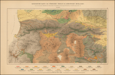
Scarce geological map centered on Los Angeles, published by the State of California.
The map was issued in the same year as the 1934 Parkfield Earthquake, the second major event since California statehood along the San Andreas Fault after it was first discovered by UC Berkeley geology professor Andrew Lawson in 1895. He determined that the fault extended all the way to Southern California following the San Francisco Earthquake of 1906, which this event supported.
This map extends from the Santa Monica Mountains and the Beverly Hills in the north and west to the Santa Ana Mountains and Newport Beach in the south and east. All the major neighborhoods of Los Angeles are named, including San Pedro, Venice, Long Beach, Anaheim, and many more.
A key to strata ranging in age from Pre-Cretaceous to Quaternary (modern) is shown to the left of the map. This names the numerous types of rocks which can be found in the area, and provides detailed information regarding geological units, including facies analysis (where sedimentary rocks were deposited) and information about the crystallinity of igneous rocks.
The many faults which can be found in Los Angeles feature prominently on the map. The famous Santa Monica, Newport-Inglewood, and Hollywood Faults zones can all be located. The Newport-Inglewood Fault is part of the fault system which acts as a boundary between the North American Plate and the Pacific Plate. Risk analysis has shown that a large rupture on the fault (Mw 7.3-7.4) could cause the first trillion-dollar natural disaster.
Importance
The map is part of California's modern history investigating its geology, including the fault lines which criss-cross the state. To put this map into context, it was printed 2 decades before geologists Mason Hill and Thomas Dibblee first proposed large-scale (hundreds of miles) lateral movements along the San Andreas Fault. Considered radical at the time, the theory has since been validated by modern plate tectonics.
One of the earliest printed maps of the area to focus on tectonic features.
![[ Highway Symbols! ] Automobile Road Map of California-Nevada Los Angeles and Vicinity Long Beach](https://storage.googleapis.com/raremaps/img/small/99652.jpg)
![San Bernardino County [and:] Southwest Portion of San Bernardino County](https://storage.googleapis.com/raremaps/img/small/96727.jpg)
![(Southern California - Oxnard to Glendale) [Composite of Eight Topographical Maps]](https://storage.googleapis.com/raremaps/img/small/95921.jpg)