


|
||

|

|
|

|
Stock# 98853
Description
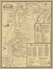
Whimsical birdseye view style map of the Coachella Valley, from the west.
The map offers a marvelous overview of the Coachella Vaelly in the 1990s, from the Palm Springs Airport in the west to La Quinta and Indian Wells in the east.
The fanciful image of downhill skiiers on Mt. San Jacinto is quite entertaining.
A fun look at the valley, which in the coming decades would expand even further east.

![[ Climatology ] Map of California Illustrating Its Climatology -- Comparative Area -- Rail Lines -- Compiled From Official and Authentic Sources By The Southern Pacific . . . 1903](https://storage.googleapis.com/raremaps/img/small/82610.jpg)

![[Santa Cruz / Holmes Lime Company] [H.T. Holmes Lot. Area 15 85/100 Acres.](https://storage.googleapis.com/raremaps/img/small/76542.jpg)