|
||

|

|
|

|
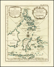
Remember the Maine! Spanish American War
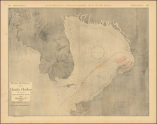
Scarce map of Manila Harbor, published by Rand McNally in 1898 shortly after the outbreak of the Spanish-American War.
The map depicts the harbor of Manilla as it appeared during the Battle of Manila Bay, fought May 1st, 1898. The chart is fairly detailed, including sounding depths for the bay and illustrations for nearby coastlines. The map also includes useful navigational details and notes to enable ships to more effectively sail in the bay.
An intriguing facet of this map is its depiction of the Battle of Manila Bay. The map, which utilized U.S. military surveys of Manila, discloses the locations of the shore batteries that defended the harbor. More strikingly, the map illustrates the deployment and line of battle of the U.S. Navy's Asiatic Squadron against the Spanish fleet anchored in Manila Bay. Both fleets are illustrated in red, as is the course of the American ships. The unusual serpentine course of the U.S. fleet as depicted on the map was the strategy that enabled their victory in Manila. Arranged in three ranks, the fleet sailed line ahead, fired their port guns then turned, firing now their starboard guns. This process was repeated five times until the Spanish fleet attempted to launch a counter-attack and flee the bay. This action was rebuffed by the powerful American fleet, though, and the Spanish were forced back into the harbor where they chose to scuttle their ships and retreat to mainland Manila.
This map offers a nice glimpse into a largely forgotten conflict in U.S. history and illustrates the pride many citizens had for their navy's actions far abroad. The quick production of this map for the 1898 Rand & McNally Indexed Atlas of the World showcases the patriotic fervor that gripped the nation during the Spanish-American War.
Rand McNally & Co. is a large American map and navigation company best known for its annual atlases. The company got its start in 1856, when William Rand opened a print shop in Chicago. He was joined in 1858 by a new employee, Andrew McNally. Together, the men established their namesake company in 1868. Originally, the company was intended to print the tickets and timetables for the trains running to and through Chicago; their first railway guide was published in 1869.
By 1870, they had shifted from just printing to publishing directories, travel guides, and newspapers. Their first map appeared in 1872 in a railway guide. The map was produced using a new wax engraving method, a cheaper process that gave the company an edge.
By 1880 Rand McNally had entered the education market with globes, wall maps, and geography texts for students. In 1923, Rand McNally published the first Goode’s World Atlas, named after its editor, Dr. J. Paul Goode. For generations afterward, this would be the standard classroom atlas.
In 1899, William Rand left the company, but McNally and his family remained, controlling the company for over a century. In 1904, they published their first road map intended for automobiles and by 1907 were publishing Photo-Auto Guides, which combined photography and mapping to help drivers. In 1924, they produced the Auto Chum, a precursor to their famous road atlases. Rand McNally would remain the leader in road maps and atlases throughout the twentieth century.
In 1937, Rand McNally opened its first store in New York City. Ever on the frontier of technology, Rand McNally pioneered the scribing process for printing tickets in 1958 and printed their first full-color road atlas in 1960. Arthur Robinson developed his now-famous projection of Rand McNally in 1969. By the 1980s, the company was exploring digital reproduction and digital databases of maps for truckers. In the 1990s, they lead the charge to develop trip-planning software and websites. Today, most of its products are available online or in a digital format, including maps for tablets and phones.
![[Manila] Manilhas Bay](https://storage.googleapis.com/raremaps/img/small/74649.jpg)