|
||

|

|
|

|
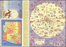
Restricted Flight Chart For Phoenix, Arizona
Chart produced by the Department of Commerce for both military and civilian use during the Second World War. The Department of Commerce and Civil Aeronautics Association, which handled matters of aviation before the Federal Aviation Act of 1958, produced this chart to reflect developments in aerial policy that came with wartime.
The chart's main feature is specific strategic information regarding Phoenix and surrounding areas. Multiple "Danger Areas" where authorities' permission is required to fly are illustrated, namely around Fort Huachuca Army Base and Luke Field Air Base. The chart also depicts the location and range of radio towers. The inclusion of this information would have been vital to civilian and military pilots navigating the area.
The map is colorfully illustrated to show elevation, a necessary bit of information for aviators in the region. The depicted area is fairly mountainous, boasting such ranges as the Black and Mazatzal Mountains. The flatter areas of the chart show the cities of the area such as Phoenix and Tucson.
Overall, a nice example of the cooperation between civilian and military authorities that aided the war effort throughout World War Two. The included data would have been a necessity for any aviator, but especially during wartime when certain areas may no longer be accessible for commercial flight.
![[ Southwest & Texas ] Le Nouveau Mexique, Avec La Partie Septentrionale De L'Ancien, ou De La Nouvelle Espagne](https://storage.googleapis.com/raremaps/img/small/99395.jpg)