|
||

|

|
|

|
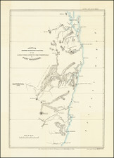
Showing Gold Discoveries in New South Wales
Rare early map of New South Wales, published by John Wyld, shortly after the discovery of gold in 1851.
The map highlights to areas where gold has been discovered along major rivers primarily in the newly formed Colony of Victoria, which had been established in 1851.
Gold in New South Wales
The discovery of gold in New South Wales was officially reported on May 12, 1851, by Edward Hargraves, a man who had previously been involved in the California Gold Rush. Hargraves, accompanied by John Lister and William Tom, found five specks of gold at Lewis Ponds Creek in Bathurst, setting off a rush that would fundamentally change Australia. While Hargraves is often credited with the discovery, it should be noted that Lister and Tom were instrumental in the actual finding of gold. Hargraves later claimed the government reward for the discovery, although public opinion often favored recognizing the contributions of his associates.
The early strikes were centered around the Bathurst region, followed by significant discoveries in the Blue Mountains and the Australian Alps. Towns such as Hill End, Gulgong, and Sofala sprang up around these goldfields, growing rapidly to accommodate the influx of prospectors. Rivers like the Turon, Macquarie, and Meroo became synonymous with gold panning, each marking its own chapter in the tale of New South Wales' mineral wealth.
The economic reverberations of these discoveries were immediate and profound. The population of New South Wales soared with the arrival of immigrants and prospectors seeking their fortune. The colony’s population doubled from 200,000 in 1851 to 400,000 in 1852. Towns became cities, and previously uninhabited areas became bustling centers of activity. Sydney and Melbourne saw a surge in their economic fortunes, acting as critical supply centers for the burgeoning mining towns.
James Wyld (1812-87) was then one of the world's leading mapmakers, holding the title of official Geographer to Queen Victoria. The present map is one of Wyld's sequences of continually updated maps of Australia and her regions, and are of great historical importance for it played a definitive role in recording the rapid progress of exploration and development during Australia's formative years.
James Wyld Sr. (1790-1836) was a British cartographer and one of Europe’s leading mapmakers. He made many contributions to cartography, including the introduction of lithography into map printing in 1812.
William Faden, another celebrated cartographer, passed down his mapmaking business to Wyld in 1823. The quality and quantity of Faden’s maps, combined with Wyld’s considerable skill, brought Wyld great prestige.
Wyld was named geographer to Kings George IV and William IV, as well as HRH the Duke of York. In 1825, he was elected an Associate of the Institution of Civil Engineers. He was one of the founding members of the Royal Geographical Society in 1830. Also in 1830, his son, James Wyld Jr., took over his publishing house. Wyld Sr. died of overwork on October 14, 1836.
James Wyld Jr. (1812-87) was a renowned cartographer in his own right and he successfully carried on his father’s business. He gained the title of Geographer to the Queen and H.R.H. Prince Albert. Punch (1850) described him in humorous cartographic terms, “If Mr. Wyld’s brain should be ever discovered (we will be bound he has a Map of it inside his hat), we should like to have a peep at it, for we have a suspicion that the two hemispheres must be printed, varnished, and glazed, exactly like a pair of globes.”
![Entree de la Riviere Endeavour dans la Nle. Galles Merid. [with] Baye de Botanique dans la Nle. Galles Meridionale](https://storage.googleapis.com/raremaps/img/small/77737.jpg)
![[ Australia & New Zealand ] La Nuova Guinea e Nuova Galles](https://storage.googleapis.com/raremaps/img/small/86442.jpg)
![Isles de Salomon [Early depiction of New Zealand!]](https://storage.googleapis.com/raremaps/img/small/101683.jpg)