This item has been sold, but you can enter your email address to be notified if another example becomes available.


|
||

|

|
|

|
Stock# 98693
Description
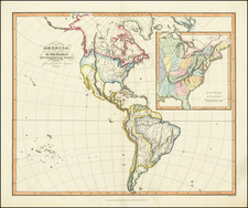
Interesting and detailed map of the United States and Canada, extending nearly to the Rocky Mountains, published in Paris by Andriveau-Goujon
Texas is named, but not yet shown as a republic, although the map includes at least a dozen place names and shows the road from Natchtoches to the Presidio de Rio Grande.
The west and old Northwest are dominated by the Huron, Sioux, Mandan, Osage and Ozark Districts, with many tribes located therein. Arkansas is shown as a territory Michigan is still a Territory. There are a number of early roads and forts located throughout the map.
One of the earliest maps published by Andriveau-Goujon.
Condition Description
Minor toning.
![(French & Indian War) The New Map of the British Dominions in North America; with the Limits of the Government annexed thereto by the late Treaty of Peace, and settled by Proclamation October 7th, 1763 [in:] The Annual Register, or a View of the History, Politicks, and Literature, for the Year 1763. Volume 6](https://storage.googleapis.com/raremaps/img/small/77573.jpg)