|
||

|

|
|

|
John Smith's Map of New England
John Smith's map is considered the most important early map of New England -- "the foundation map of New England cartography, the one that gave [New England] its name and the first devoted to the region" (Burden 187).
After a period of inactivity following his Virginia expeditions, Captain John Smith was invited by a group of London merchants to explore the coastline north of Virginia, with instructions to return with a profitable cargo. Smith arrived off the Kennebec River with two ships. Smith immediately recognized the poor state of the existing cartography for the region. He noted that he had six or seven maps:
of those northern parts, so unlike each to other, and most so differing from any true proportion, or resemblance of the Countrey, as they did me no more good, then so much waste paper.
He then set about surveying and constructing a proper map of the region, just as he had for Virginia several years earlier. Returning to England in December 1615, Smith had the map published with his A Description of New England in June 1616. According to a legend on the map, much of the nomenclature was provided by Charles, Prince of Wales, the future Charles I. Several of these placenames are still in use, including Cape Anne, Charles River, and Plymouth.
The map was engraved by the outstanding Dutch engraver, Simon de Passe, who worked in London from 1616 to 1621. De Passe added a number of finely engraved decorative elements. He was most famous for his portraits, and here includes a striking depiction of Smith. Griffiths notes that de Passe's English portraits "marked an epoch not only in the British print but in the development of the European portrait engraving," most importantly for his introduction of "a new type of auricular frame … It is curious that such an advanced type should first be popularized in England."
The separately dated ("Ao 1616") portrait of Smith on the map, which may have been de Passe's first published in England, predates his use of the auricular style. But the "scale of leagues" in the lower right corner clearly exhibits the "extraordinary curling and folding decoration" that typifies the auricular, and which de Passe soon incorporated into his portrait frames. The auricular quickly became a hallmark of the Baroque style.
States of the Map
The map is known in 9 states. The present map is state 8, which can be differentiated as follows:
- State 7: Primary changes include a change to the title: "Prince Charles is described as 'nowe King of Great Britaine . . ."
- State 8: Primary change includes the addition of the Arms of the Council for New England, with motto 'GENS INCOGNITA MIHISERVIET', have been added off the coast of Cape Anna.
- State 9: First to show the correct position for Boston, and the first to name Charlestown. Other significant change includes the addition of a note below the compass rose reading "'He that desyres to know more of the Estate of new England lett him read a new Book of the prospecte of new England & ther he shall haue Satissfaction"
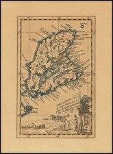
![[ St. Lawrence / New Brunswick /, Nova Scotia / Quebec ] Carta Rappresentante Il Golfo del Fiume S. Lorenzo](https://storage.googleapis.com/raremaps/img/small/99719.jpg)