


|
||

|

|
|

|
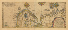
Fascinating map showing Scandinavia and the Baltic region based upon the description of ancient geographers, such as Ptolemy, Pliny the Elder, and later, Adam of Bremen and Cluverius.
As noted in the text explanation, the map derives from a blend of geographical descriptions and historical references. The text translates as follows:
"SCANDIA, to Ptolemy, is Scandinavia to Pliny, an island of the same uncertain magnitude, to the older Greeks it is Baltia or Basilia, and to others, Scanzia. According to Adam of Bremen, Sconia is a peninsula, not an island, just as with Finningia whose inhabitants are the Fenni or Finns.
Mount SEVO itself is vast, not smaller than the Riphæan hills, and marks the beginning of Germany to the north. It is inhabited by the Ingevones, from whom, after the Scythians, the name 'German' arises, as noted by Solinus.
The greatest of all islands is Nerigon, from which one sails to Thule, now known as Iceland, according to Pliny.
The Lupiones are mentioned as armed in the Itinerary tables, called Loppi by the Riphæans or Russians, by the Danes, Swedes, and Norwegians as Lapper, and by the other Germans as Lappen, according to Cluverus.
This text provides insight into various historical and geographical interpretations of the regions of Scandinavia, reflecting the understanding and naming conventions of different historical periods and cultures. The descriptions involve ancient geographers and historians like Ptolemy, Pliny the Elder, and later, Adam of Bremen and Cluverius, who have each contributed to the knowledge of this region. It mentions significant landmarks and peoples, including the Fenni or Finns, and addresses the complex interplay of geography, culture, and history in the naming and understanding of these lands.
![[Spitzbergen & Wiches Lande]](https://storage.googleapis.com/raremaps/img/small/61990.jpg)
![[Heightened in Gold!] Pas-Caart van de Oost Zee Verthoonende Alle de ghelgentheydt tusschen 't Eylandt Rugen ende Wyborg. Op nieuws oversien en verbeetert. . . 1665](https://storage.googleapis.com/raremaps/img/small/83731.jpg)