|
||

|

|
|

|
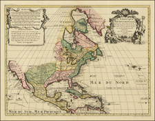
Scarce map of North America, published shortly after the conclusion of the Mexican War in 1848.
In the west, a massive California is shown, pre-dating the creation of Utah Territory, with New Mexico shown, but prior to the 1850 Compromise with Texas, which would create the boundaries for Texas and New Mexico Territory.
Sutterville and Sacramento are shown, but prior to the discovery of gold in California. Mormon Fort° appears on the east side of the the Great Salt Lake.
Oregon Territory is shown, along with a few early settlements, including Oregon Cite (Oregon City), but all the other Oregon Territory settlements are Fur Trading forts.
The border between Oregon Territory and British Canada is belatedly shown at 54° 40", the maximum claim made by the Americans prior to the resolution of the boundary under the 1846 Oregon Treaty.
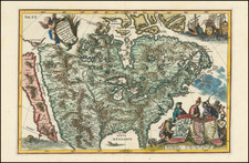
![[Unusual Italian Immigrant Communities shown!] America Settentrionale, Centrale e Meridionale -- Carta Dimostrativa Delle Ambasciate, Legazioni, Consolati (Con Le Risettive Circoscrizioni Territoriali), Camere Di Commercio, Agenzie Commerciali, Stazion Enotecniche, Uffici Postali, Ospedali, Scuole Governative e Sussidiate All'Estero](https://storage.googleapis.com/raremaps/img/small/86098.jpg)

![(North America) ПОЛИТИЧЕСКАЯ КАРТА СЕВЕРНОЙ АМЕРИКИ. [Political Map of North America]](https://storage.googleapis.com/raremaps/img/small/90261.jpg)