|
||

|

|
|

|
Eye Witness Accounts of the Battles During The Spanish Campaign In Flanders (1601-1609)
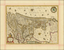
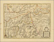
Fascinating early map of a portion of Holland, illustrating the region centered on the Ijssel River and Waal River, illustrating Pompeo Giustiani's account of military events during the Spanish Campaign of 1601-1609.
Italian soldier Pompeo Giustiniani, was born in 1569. By the age of 18, he had hired on as a soldier in the service of Spain and was in Flanders in 1587, fighting for the Spanish, as a captain in the army of Alexander Farnese. In 1601 he began serving under Ambrogio Spinola, commander of the Spanish forces fighting for the Archdukes Albert and Isabella, with the rank of sergeant major. In 1603 he took over the leadership of the Spanish infantry of Spinola, then was promoted to the rank of field marshal.
In 1604, he faced Maurice of Nassau in the battle for the port of Sluis and Damme city. On September 22, 1604 during the siege of Ostend, the walled city which would not surrender, he had his right arm destroyed by a musket ball, which was replaced by a metal prosthesis and was nicknamed "Bras de Fer". In October 1605 he presided over the surrender of Wachtendonck, and the capitulation of other Dutch positions. Giustiniani would go on to fight for Venice in1613, rising to the level of captain-general, and had an equestrian statue built in his honor in San Giovanni e Paolo in Venice. On October 10, 1616, he died in battle at Lucinico.
The map is annotated to tell the stories of key military figures and their maneuvers, which provides a layered historical narrative of strategic military actions during the Eighty Years' War in the Netherlands. These include:
A. Ambrogio Spinola leading his Spanish Army: A Genoese nobleman who financed his own army and served the Spanish crown. Noted for his siege expertise, particularly during the Siege of Ostend (1601-1604), and his campaigns in the Spanish Netherlands.
B. Maurice of Nassau: Prince of Orange and a key leader of the Dutch revolt against Spanish rule. His campaigns included a series of successful sieges which strengthened the position of the United Provinces. Here his positions are shown on the north side of the Waal and Ijssel Rivers.
C. Pompeo Giustiniani: An Italian commander, noted for his participation in the Siege of Ostend and his military treatise. He was known as 'Bras de Fer' after losing an arm in battle. In this image, his forces are shown on the Waal River, below Nijmegen.
D. Conte di Sora: Likely referring to Charles Bonaventure de Longueval, Count of Bucquoy, a military commander who fought in the Spanish Army of Flanders and later commanded the Imperial Army during the Thirty Years' War.
E. Fortifications: Reflecting the Dutch ingenuity in military engineering, these fortifications on the north side of the rivers were likely constructed under the direction of Maurice to resist Spanish advances.
F. Count of Bucquoy (Buqnoy): Charles Bonaventure de Longueval, engaged in various battles for the Spanish and later for the Holy Roman Empire, demonstrating his military prowess throughout the region.
The map notes several other important features, including:
-
Fort Schenke, A reference to Fort Schenkenschanz, which was a key strategic point during the Eighty Years' War, associated with efforts by Martin Schenck von Nydeggen, who famously attempted an assault on Nijmegen in 1589.
-
The Waal and IJssel Rivers, along with the cities of Zwolle and Sluis, were critical locales for military maneuvers and battles. Control of these waterways was essential for both defensive strategies and for the movement of troops and supplies.
![[ Rotterdam ] Roterodamum, Hollandiae in ostio Roteri Flu Opp. Magni il:lius Desiderij Erasmi Patria](https://storage.googleapis.com/raremaps/img/small/96869.jpg)