


|
||

|

|
|

|
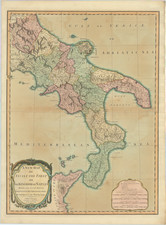
Goregous old color example of Blaeu's map of the Southern part of the Grand Duchy of Tuscany, including the Duchy's of Siena and Castro.
The map shows the Duchies of Siena and Castro in the second half of the 17th century . This era in the Sienese territory and the Duchy of Castro is particularly reflective of the larger political, cultural, and economic currents sweeping through Europe following the Thirty Years' War.
The city of Siena, once a proud and independent medieval commune, had been under the dominion of the Grand Duchy of Tuscany since 1555, when the last Sienese Republic fell to the forces of the Medici Duke of Florence, Cosimo I. Throughout the 17th century, Siena was governed by the Medici and later their successors, the House of Habsburg-Lorraine, which maintained its rule over the area, integrating its administration with the wider Tuscan policies. The Medici's focus was on reinforcing their absolute power, fostering the arts and sciences, and promoting agricultural development, which led to a period of economic stability and growth for Siena.
Meanwhile, the Duchy of Castro, a fief of the Papal States, had a more tumultuous history. Established in the 16th century by Pope Paul III for his family, the Farnese, it became a point of contention throughout the century. The War of Castro (1641–1649), a conflict that embroiled the Papacy, the Farnese, and several other Italian states, ultimately led to the destruction of the city of Castro by papal forces. After the war, the territory was reincorporated into the Papal States, and the Farnese influence waned, marking the end of the duchy's autonomy.
The second half of the 17th century for both Siena and the defunct Duchy of Castro was a time of consolidation. Siena, under the Habsburg-Lorraines, experienced a period of cultural and academic flourish with the foundation of the Accademia dei Fisiocritici, which promoted scientific inquiry, and the enhancement of its university. The city maintained its reputation as a site of intellectual and artistic patronage, despite its political subjugation.
In contrast, the former lands of the Duchy of Castro were absorbed into the administrative structure of the Papal States, their resources exploited to rebuild after the destruction of the war. The papacy, under the reign of Alexander VII, endeavored to fortify its central authority, embarking on a series of infrastructural and architectural projects, which aimed at both the revitalization and the assertion of ecclesiastical power.
The map includes 2 cartouches, sailing ships and a compass rose.
Willem Janszoon Blaeu (1571-1638) was a prominent Dutch geographer and publisher. Born the son of a herring merchant, Blaeu chose not fish but mathematics and astronomy for his focus. He studied with the famous Danish astronomer Tycho Brahe, with whom he honed his instrument and globe making skills. Blaeu set up shop in Amsterdam, where he sold instruments and globes, published maps, and edited the works of intellectuals like Descartes and Hugo Grotius. In 1635, he released his atlas, Theatrum Orbis Terrarum, sive, Atlas novus.
Willem died in 1638. He had two sons, Cornelis (1610-1648) and Joan (1596-1673). Joan trained as a lawyer, but joined his father’s business rather than practice. After his father’s death, the brothers took over their father’s shop and Joan took on his work as hydrographer to the Dutch East India Company. Later in life, Joan would modify and greatly expand his father’s Atlas novus, eventually releasing his masterpiece, the Atlas maior, between 1662 and 1672.
![[Tuscany / Florence] Dominio Fiorentino](https://storage.googleapis.com/raremaps/img/small/96548.jpg)
![[Corsica, Sardinia, Northern Italy]](https://storage.googleapis.com/raremaps/img/small/56055.jpg)