|
||

|

|
|

|
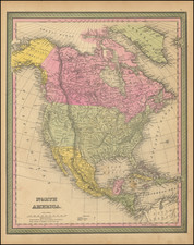
North America After Lewis & Clark
The true first edition of Brue's map of Map of North America, known to Wheat only by the later 1825 edition.
The map is a marvelous post-Lewis & Clark production, combining excellent detail from the expedition in the Northwest with information from Pike, Humboldt, and others. The Phillipe ou Rio del Colorado flows from Monterey to Both Lake Teguayo and Timpanago and then onward even further toward the Rocky Mountains.
The primary region shown in the Western United States are "Haute Louisiane" (Upper Louisiana) and District de L'Columbia (Columbia District).
Excellent detail in Texas. Double-wide Arkansas Territory. Remarkable Indian details.
The Missions of Upper California are named. Single Cordillera, as described by Humboldt. Excellent detail in Western Canada and Russian America.
Rarity
The first edition of this map is rare on the market.
This is only the second example we have offered for sale in over 30 years.
Andre Hubert Brué was a French geographer and cartographer. Born in Paris, he served in the French Navy, joining the Baudin expedition to the Pacific (1800-1804). After his sea service, Brué applied his navigation and charting skills to creating finely-crafted maps, which were renowned for their crisp engraving and accuracy. He drew directly on the copper of the plate, creating what he called encyprotypes. He is best known for the Atlas universal de géographie physique, politique, ancienne et moderne.